Cape Fear Rest Day
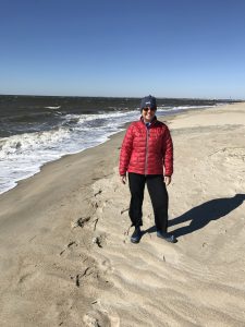
Shelly Models Her “November in North Carolina” Beachwear
We went for a long walk today around Cape Fear, windy and brisk in November. No beachgoers but blue skies without a cloud in sight. It was cold enough that we had to wear our winter beach clothing, as Shelly shows above. The island is replete with empty vacation homes, it reminded us of the resort area in Steamboat, nice big houses with no one home. No cars are allowed on the island, but speeding golf carts are a problem as we found walking down the roads. The only way to get here is by ferry (or your own boat) that comes once an hour and costs $23 one-way from the nearest town of Southport.
We walked past the Cape Fear lighthouse, pic below. Originally built in 1789. The island was prominent in both the Revolutionary War and the Civil War. In the Civil War it was one of the last Confederate holdouts whose forts have now been submerged due to climate change.
We hunted for alligators but didn’t find any. Probably too cold!
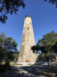
Cape Fear Lighthouse
ICW Mile 309: Cape Fear Inlet
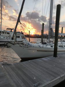
Sunset Over Good Karma
Got up early today and motored about 25 miles down the ICW to the Cape Fear inlet. Lots of funkyness. The channel was narrow and very busy, mainly with private fast-moving fishing motorboats. The main challenge was dealing with the high currents in the channels that make it difficult to control the heading and speed. The tidal range has been about 5 feet and that equates to a lot of water moving in and out of narrow openings. You can see the effects around the channel marker posts and buoys, they appear to be in a fast moving river with a wake behind them.
We had to get moving early again today to get under a bridge at relatively low tide. After the bridge the current was hard against us so it took about two to three times as long to get to our destination, making the day about 6 hours before we docked.
Our marina is on Bald Head Island, my kind of place! It’s fairly protected for the gale force winds expected tonight and tomorrow. We are here for two nights to wait out the front coming through. Today was nice but windy but the next few days promise to be cold. The tradeoff for us is all the marinas and anchorages we have stayed in have been sparsely populated.
On a learning note: We got way too close to a dredging operation in the channel, pic below. You are supposed to remain 500 feet away because they anchor these barges on long cables. We happened to cross over at least one of those cables trying to stay in the channel and not knowing what exactly was going on. We hightailed it away when we figured out what was going on, being lucky not to have hit a cable.
Our improvised radio has been working but not ideal. We were probably warned about this operation but didn’t understand the distorted signal due to having the radio volume too high. Now fixed.
Tomorrow is a well-earned rest day. Going’ to hunt gators!
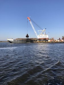
Big Dredging Operation in the Channel
Posted in Sailing by Mark with comments disabled.
ICW Mile 285: Masonboro Inlet

Crews Work In Predawn Hours on a Grounded Ship
Big, big day today. Accomplished a few firsts. We had our longest transit to date, about 70 miles across Onslow Bay between Cape Hatteras and Cape Fear, NC. We had our first open ocean sailing experience on Good Karma, and for the first time (for me anyway), I was far enough out to sea on my own boat as to not have any visible land anywhere. The caveats here are that we barely had a “sailing” experience today because the wind was so mild, and we were only 15 miles from land at any time, so it wasn’t like real open ocean sailing.
So here was the deal: Here you can go out to the Atlantic and bypass about 80 miles of some of the worst parts of the ICW channel but it’s a long day. To do this you exit to the sea at the Beaufort Inlet south of Cape Hatteras. The nearest return is the Masonboro Inlet just north of Cape Fear. It takes about 12 hours to get across this section under moderate conditions, from leaving dock in the morning to anchoring at night. Being the third week of November, there are only about 11 hours of daylight, counting the predawn and post-sunset useable twilight. So you have to do something in the dark and we chose to leave at zero dark thirty.
We winded down and out the Beaufort Inlet channel relying heavily on navigation instruments as we did a few days back when our anchor drug. This time we were avoiding other boats doing the same thing, as well as UNLIT anchored boats (what are these people thinking?!?) on the exit route. It was a bit harrowing, but we made it ok. As we got out to the ocean we passed a big cargo ship that had gone aground the day before. Crews were working frantically to get it unstuck, we could hear them shouting as we passed (above pic).
After we got out to sea we had enough wind to motorsail. The wind direction and speed was not enough to give us the velocity we needed to get to our destination in a reasonable time so we had to motor the entire way. Our engine droned on for twelve straight hours. The sails did give us an extra knot of speed, though, which over the long run shaved more than an hour off our motor-only time. And we needed it. The sun set just as we got an anchor set. Anchoring in the dark would not be anyone’s idea of fondly remembered good times, especially when there are many other UNLIT boats anchored in the area, as there are here.

The Path of Good Karma is Not a Straight One
Our AIS seems to be tracking well on the website. The above track shows an overview of today’s route. Note that it is not a straight line as you might expect, but bows toward the ocean. This is what you must do to avoid the Camp Lejeune live firing range, which extends 15 miles offshore. The military uses this range every day. We heard lots of rumbling booms of the live firing but didn’t receive any direct hits, which is a good thing…
The coolest thing we saw today was again, the dolphins. Two times we were escorted by a group who seem to think Good Karma is a giant dolphin. They always gather around and swim right next to us for five or ten minutes sometimes. The first group came in and were jumping occasionally but not a lot, so Shelly walked up to the bow and looked down. They were swimming right in front of the boat and along side as if to guide us. Three of them were leading, two adults and a young one. I got a great video of two of them, the little one is visible only in the first couple of seconds unfortunately. I had to name the little one “Bob” at the request of our niece Hannah who would probably want us to ship it home for her.
Great progress south today, it even feels warmer!

Sunrise Over The Atlantic
Posted in Sailing by Mark with 2 comments.
Busy Day in Beaufort

Old Radio Out, New One In
We spent most of the day today shopping, doing laundry and trying to get a new workable radio set up. Caught a ride into town with another crew that is getting their boat repaired, we were going to the same marine supply store and grocery store. Bought some bibs, deck shoes, life lights (lights for our life vests) and a new VHF radio.
The old radio worked fine but the remote control head started flaking out. The radio itself is below deck at the electronics station, but it’s generally worthless there because you can’t use it from the cockpit from there. The remote control head allows you to talk, listen, change channels and volume from the cockpit. That is about the only place you use the VHF radio, so it’s critical to get fixed. The marine supply store of course did not have the entire system, so we are here until Thursday at least.
I did get the radio mounted, which is the white radio in the above pic. The hole in the wall is where the old radio was mounted. Looks a bit ugly at this point but we will clean it up in Florida when we get to a long layover point.

Sunset Off the Starboard of Good Karma
Posted in Sailing by Mark with comments disabled.
ICW Mile 202: Beaufort, NC

Supermoon Over Bear Creek, NC
We finally made it to Beaufort (pronounced BO-fort), the first place where we can finally go offshore into the ocean and out of the infernal ICW! Yesterday was a relatively short, calm day that became downright warm as we anchored in Bear Creek. Today we decided to get all the way down to Beaufort, about 40 miles and 7 hours of motoring. It started out very rainy and windy, up to 30 knots (predicted to be 10-15) and some big waves. But after a while it settled down and became calm and balmy. We went under yet another bridge, timed to go under at low tide, but had zero problems getting under it.
After many hours of motoring, we were a bit frazzled as we came to the last section into Beaufort. As we came in we were greeted by a huge uncharted bridge under construction. It was about 68 feet high so no problem getting under it, but right before the marina they were also doing construction in the channel and all the navigation markers were messed up. The marina directed us in and Shelly got Good Karma into a tight, difficult slip with no problem. She looked downright professional!
We are in Beaufort for at least two days, shopping, working on the boat and recovering from the last week of ICW “magic.” At least it won’t freeze here!

Good Karma at Beaufort, NC!
Posted in Sailing by Mark with comments disabled.
ICW Mile 136: Belhaven, NC

Hooked A Champion!
Look closely at the above picture and you’ll see a five foot long log. It is hooked underneath the anchor, our trophy from last night. Here’s the story:
Went to bed just south of Cypress Point last night in perfectly calm, glasslike conditions. We knew there was a forecast for increased wind overnight starting at about midnight and we were in a relatively exposed position to north or south wind. There aren’t any well protected anchorages in this area for quite a distance. We weren’t too worried because the anchorage was recommended as having good holding, the forecast was for wind from the northeast, not north, and it was very peaceful early in the evening. What could go wrong?
About midnight, the wind picked up and the boat started rocking a lot. We got up to check things out and it was very wavy with lots of wind under the full supermoon. We noted our position by looking at the slow flashing red lights of the navigation beacons off the port side. They were in the same place as where they were when we went to bed, so the anchor was holding. Shelly got a bit worried and so got dressed just in case we needed to get up and take care of the boat in the middle of the night. I just went back to sleep.
It continued to rock quite a bit but we did get some sleep. I woke up at about 2 a.m. and went up to check our position again. The wind had picked up even more and the water looked very chaotic. Our position was still ok, the red flashing navigation markers were in the same place off the port side. I went back to bed.
The rocking action of the boat decreased somewhat for the next hour and changed from front-to-back to side-to-side, a much easier ride. After a while I got a bit curious about the side to side rocking and wanted to check the wind speed, it seemed higher than predicted. The time was 3:15 a.m. I looked out and did not see the red flashing navigation beacon where I expected and noticed the moon was setting behind the boat. I thought the wind must have shifted direction and we were pointed more to the east. If that were the case I should see the red flashing light off our stern and there was nothing back there. Hmm. I looked some more and saw a red light in what I thought was the correct place and so my concern subsided. But why was the moon in the wrong place?
I went below to turn on the chart plotter which would show me exactly where we were. Well, it told me we were about one mile from where we started. A nautical mile. On top of that it showed we were drifting at about 1 mile/hr, dragging the anchor. That was NOT good. These “magic moments” always happen at 3:30 a.m. for some reason.
I got Shelly up and we donned full battle gear, including life jackets, and went to work getting control of Good Karma. It was rocking quite a bit and the wind was blowing over 20 knots. The moon was almost down so not much light. Shelly went forward and worked on getting the anchor up, a tough job made more difficult by the cold, high wind and rocking waves. I got the motor going to take pressure off the anchor chain. After about 10 minutes Shelly got the anchor onto the deck.

AIS Track
The pic above was taken from our AIS track and shows how far we dragged across the channel. We’re moving south, toward the bottom of the pic. The drag part of the track is the right-to-left going down slant in the “Z” shape in the center. We anchored at the top corner of the Z and got control at the bottom corner.
It was then 4 a.m., first light would be at 6:10. We decided to continue running down the channel at slow speed rather than try to anchor again in those conditions. Off we went, navigating by instruments and the few lighted navigation beacons, hoping not to run over a crab trap. Every time the chart plotter showed an unlighted navigation pylon, we would spot light it with our powerful flashlight. It was very difficult to keep in the channel with the waves and the wind, but not impossible. We slowed down as much as we could so as to not try to cover a lot of unseen territory, remaining in the channel and waiting for daylight. The wind was freezing, but we had fairly good protection under the cockpit canvass.
We had two hours of dark navigation. We heard on the radio other boaters who “went to sleep on one side of the channel and woke up on the other side.” Adding to the eeriness, the Coast Guard was periodically broadcasting a “pan-pan,” to be on the lookout for a boat in distress further down the channel, based on a signal flare seen at 2 a.m. The sky started to glow as we got to the Alligator Canal, our next canal section about 15 miles long.
The wind died down to near zero in the canal and the sky brightened. Our moods brightened with the sky. Shelly made some hot coffee and a breakfast snack (thank you!) as we calmly cruised down the channel. She said, “check out the log on the anchor.” She had told me about it long ago but now it was very visible. Our anchor hooked that log and is likely why we drug so far, the anchor couldn’t dig into the mud.
Lastly, as if that wasn’t enough excitement, we were approaching the notoriously low Wilkerson Bridge. It is the bridge that has a reputation as being lower than 64 feet. The waterline scale showed on approach that it was about 63.5 feet. We approached and things otherwise looked good, no other boats in sight to cause wake waves and bounce our mast into the bridge. We held our breath and passed under it. Did not even touch the top of the antenna! My measurement of our top-of-antenna mast height was 63.5 feet was accurate. Just slipped under!

Wilkerson Bridge Behind Us!
Today we’re anchored at Belhaven, which looks like a cool little town to visit but we’re too cold and tired to get off the boat tonight. Some other trip.
Posted in Sailing by Mark with 2 comments.
ICW Mile 90: Cypress Point on Alligator River, NC

Alligator River Swing Bridge Opening Ahead
Today we woke up to about 50 degree weather today and crossed the Albemarle Sound, a relatively open body of water about 15 miles wide. It was a bit windy and we got our share of waves, but there were only a few crab pot floats which can be a problem in this area.
As soon as we approached the far side of the sound the wind died down and it warmed up nicely to just under 70 degrees. It was a nice break from the string of chilly days we’ve had. Unfortunately, tomorrow is going to be much cooler again.
We entered the wide Alligator River where apparently a few have been seen. More common are swimming black bears. Really. We haven’t seen one yet but the day isn’t over. We went through the Alligator River Swing Bridge which opened immediately upon our radio request. It’s kind of cool, they stop all the traffic for about 10 minutes to get the bridge open, wait for you to go through, and close again. Like waiting for a train at a railroad crossing I guess.
Tonight we are anchored at a spot that looks very similar to the spot we were in last night. The shoreline is wilderness, there are no other boats around and it’s very peaceful.
Amazingly, the AIS is still working. This is where we are. If you click on the “track” button on left you can see our track which is accurate. You can probably see our progress in real time as we are underway during the day.
Today was not too long and the next few should also be reasonable.
Posted in Sailing by Mark with comments disabled.
ICW Mile 57: Buck Island in North River, North Carolina

Cruising the Long, Straight Albemarle and Chesapeake Canal
It was a long and winding voyage today. And cold. I’m beginning to think the “IC” in ICW stands for icy. Well, I guess we waited a little longer than most but it seems a bit colder here than it should be. The good news, we are getting further south! Traversed about 45 miles of the waterway today and it took about 7 and a half hours. Went through two swing bridges and under three more low 65 foot bridges.
We are continuing to find that the waterway is kind of a traffic nightmare. We’ve met some very friendly, helpful boaters as well as total jerks. The jerks have all been in power boats. Not all power boaters are bad, but there are definitely bad apples who pass you with big wakes and don’t signal. Much of the waterway is a narrow dredged channel so passing has to be done in close quarters. When a power boat zooms up to your stern and then slows to pass, they usually throw a wake wave which knocks your steering off. This is not a legal maneuver but there’s always a power boater willing to piss everyone else off, including other power boaters.

It Became Sunny but Windy as the Day Progressed
We swapped steering duties every hour so that we wouldn’t get too tired. Keeping in a narrow channel, even those that are straight-line for miles, is more difficult than it sounds. Wind, currents and waves constantly mess with your course and you have to correct. Lots of winding through rivers as well.
We finally arrived at our planned anchorage near Buck Island. It was pretty windy when we arrived but has subsided a lot. No worries about the tide in the waterway here, but the wind can push water in and out. We’ve had north wind most of the day but the depth here is 10 feet, great for anchoring.
The AIS data is apparently working well in this area and this is where we are.

Our Lonely Anchorage for the Night
Posted in Sailing by Mark with comments disabled.
ICW Mile 12: Portsmouth to Great Bridge

Gates of the Lock Closing in Background
Today was unique and very busy watching for other traffic and communicating on the radio. We left the marina in Portsmouth and headed down the most congested section of the ICW, though not so bad for us as most of the private boat traffic is about three weeks ahead of us. The first bridge was right out of the marina, a railroad lift bridge that is normally open, but was closing as we approached. It wasn’t for a train but for maintenance. We circled around for about 45 minutes until they opened the bridge. A tug with a huge barge asked us to move out of the way while we were sitting there (thanks AIS). You can’t just pull over and put the breaks on, you have to do fine maneuvering, which is difficult in a sailboat like ours. Essentially, we sit and slowly spin clockwise to keep in place. There were about 5 other boats waiting with us, making it fun avoiding them.
When they raised the bridge, they took it up to only 65 feet. This was a great test for our mast clearance. We got under it and man was it close. A few miles later we went under another 65 foot fixed bridge and dinged the very top of our antenna. No problem, but we know that going under the 64 foot bridges ahead we will bend the antenna a bit. Shouldn’t be a big problem. We think.
We steered down the narrowing waterway until we got to the Great Bridge Lock. This is the only lock we have to go through. They open the gates at about 15 minutes past the hour, you get into the lock and moor your boat to the side right behind the boat in front of you (pictured above). They then close the back gate and open the front gate. The water rises a couple of feet and you proceed out to another bridge that is coordinated to open shortly after the lock fills. When that bridge lifts, you have fun avoiding the northbound traffic trying to get into the lock.

Shelly Guiding Good Karma Out of the Lock
There are docks just outside the lock and we easily picked up a place for the night. We are at a place called Great Bridge, an important historical location as this was where the British forces were first defeated in the Revolutionary War.
AIS reception seems to be working well and so this is where we are today.
Posted in Sailing by Mark with comments disabled.
Mobjack Bay to Norfolk, VA: ICW Mile Zero

Shelly Bringing Up the Staysail to Dry Out Before Storage
We are spending election day here in Portsmouth, Virginia, across the river from Norfolk, getting prepped for the long haul down the ICW and avoiding the news. Yesterday we had another wild, windy ride from Mobjack Bay to mile zero of the ICW. Lots of wind and waves! We even had a lone dolphin check us out, jumping out of the water between the 5-foot waves.
We are now officially out of the Chesapeake Bay, having sailed nearly the entire length. We entered the Elizabeth river, the beginning of the ICW, and man is it busy here. This is one of the busiest shipping channels in the U.S., with the naval station and shipyard, as well as lots of commercial traffic.

Aircraft Carriers at the Shipyard
Luckily, there wasn’t much commercial traffic and as planned, not a lot of private traffic heading to the ICW. There were several barges we had to avoid in the channel, as well as the container ship below. That container ship came out of one of the side yards and turned right in front of us. Well about a mile in front of us, which is pretty damn close. You have to pass almost next to them in the channel. Exciting.

Watch Out, Container Ship Being Towed Out!
Tomorrow we head down the ICW, going under a bunch of bridges and through the one lock on this section of the ICW. We’ll only get about 12 miles, but it should be one of the more difficult portions of the waterway. Got to keep moving, it got down to 40 degrees F last night. Might as well be winter camping in Colorado…
I see that vessel finder is working here because this is where we are.
Posted in Sailing by Mark with comments disabled.