Outfitting a Nuclear Physics Lab

Geiger Counter Kit
Ok, it turns out that to build a nuclear fusion reactor you basically need to start with a nuclear physics lab. Since I don’t have access to one, I decided to outfit my own lab in my garage. The first order of business was to acquire a Geiger Counter, an instrument to measure radiation. I looked around on eBay and found that professional-looking Geiger Counters cost $400 and up, a bit steep. This is just one of the instruments I need and am on a budget, so instead I found a build-it-yourself kit. For $136.46 (including shipping), I can build my own Geiger Counter, saving at least $300.
A Geiger Counter is necessary for safety, to know if you are pushing into harmful radiation limits. Unfortunately this counter is not calibrated, doesn’t have a meter and the electronics would probably be destroyed if exposed to “a lot” of radiation, whatever that amount is.
But what the hell, it probably works, lol!
Posted in Nuclear Fusion Reactor by Mark with comments disabled.
Journal

Thinking about building one of these…
Haven’t been very motivated to write much in the last two weeks or so, probably because I haven’t had any interesting adventures. That, plus work, work, work…
Last weekend we were in Steamboat and it was amazingly green, it reminded me of Oregon. Unfortunately I didn’t get any good pics because I forgot my camera at home and the pics I took with my iPhone aren’t that great. Plus I can’t get them to download on my mac for some reason.
Ok, my last post about the Steamboat Marathon, which was run last Sunday. I didn’t actually run it or really even consider it. The posting was an inside joke of sorts. What happened was that in 1992 we went to Steamboat to hang out with some good friends, a couple who was running the marathon. Their race would be the culmination of an extensive and very difficult training regimen they had stuck to for many months. Being a runner myself, I knew how much they suffered to get to that point. I had been training myself but nowhere near the distances they ran, which was about 20 miles regularly. But I did want to run at least one marathon in my life and so… At the last minute I signed up for the race. I thought what the heck, it’s generally downhill and I could probably get through it. I did and was able to struggle to the end, the last 8 miles were excruciating. Both of my friends had rough days, as can happen to anyone, and surprisingly I finished ahead of them. I got lucky, or rather they got unlucky. And of course they’ve been harassing me about this for the last two decades. This is called the Balthazar effect.
So… The photo at the top is a nuclear fusion reactor. Turns out that it is possible to build one of these at home. More on this later…
Posted in Journal by Mark with comments disabled.
Marathon Decisions
Up in Steamboat this weekend and saw the Steamboat Marathon is running tomorrow. Trying to decide if I should run it or not.
Posted in Journal by Mark with comments disabled.
Journal
Possible Sealcat sighting in Boulder?
Well this spring is shaping up to be more normal than the previous two years when we had sweltering, dry weather. Last weekend it warmed up enough to start the big runoff. Lots of snow remains in the foothills and the high peaks look almost solid white. Even Pikes Peak is largely covered snow. 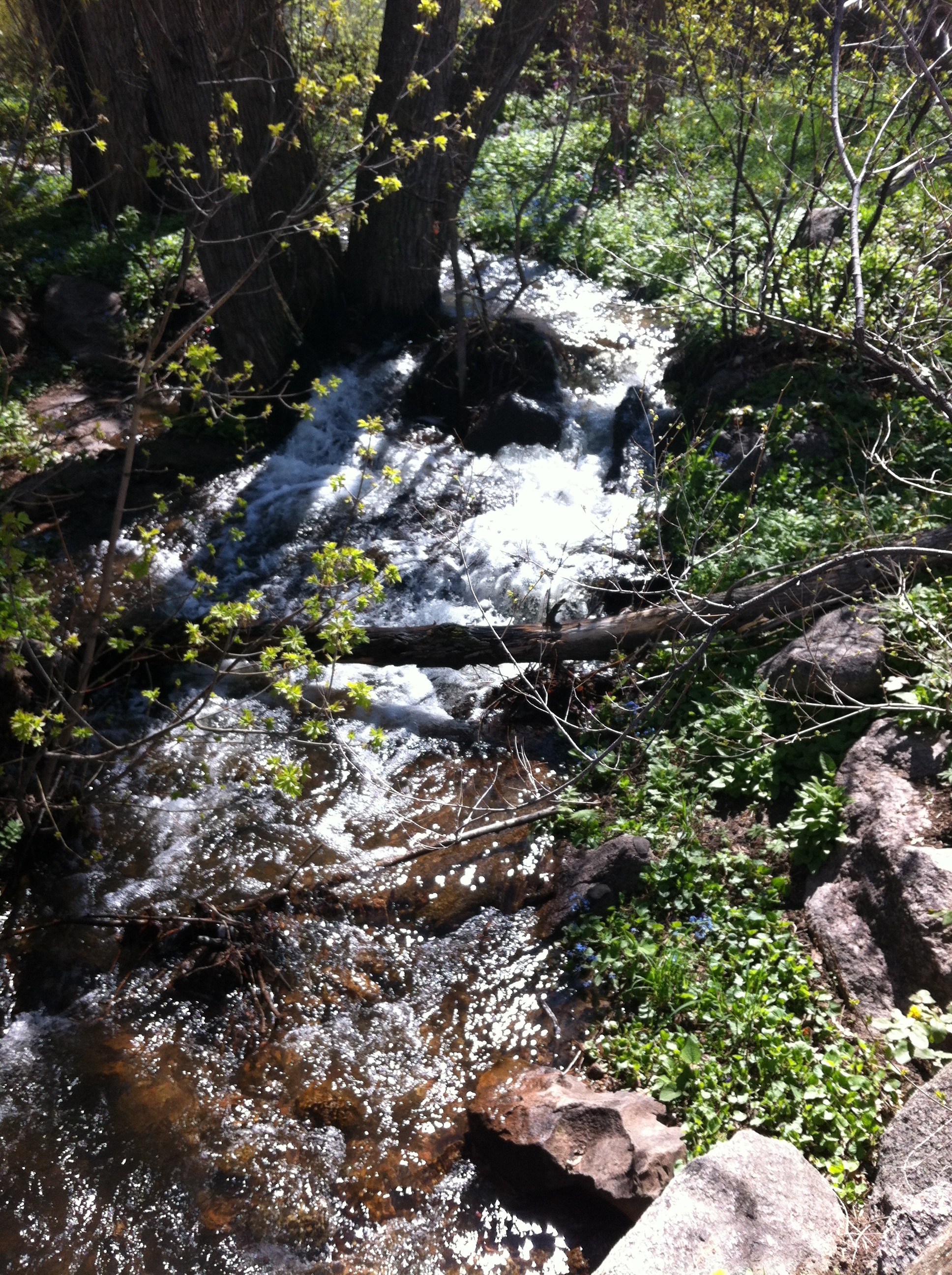
Gregory Creek which flows just behind our house was running for the first time in probably three years, pic on right.
—————————————————————-
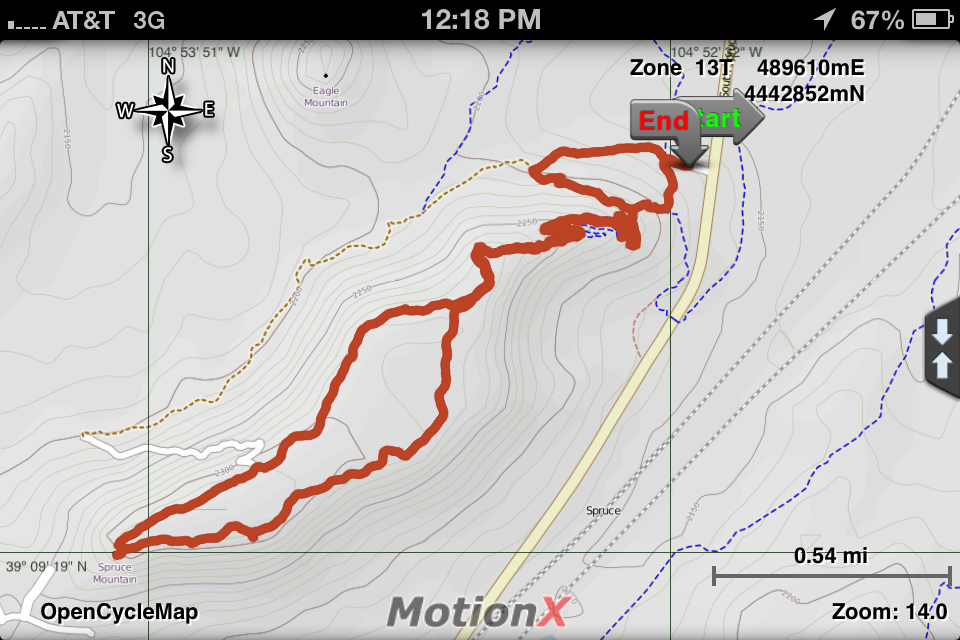 On Sunday we visited Colorado Springs for Mom’s day (hi mom!). On the way home we hiked in a cool open space area just north of Palmer Lake called Spruce Mountain Open Space. GPS track on the left. There is a large trail system for both hikers and mountain bikers. It winds around Spruce Mountain, which is one of the buttes between Castle Rock and Monument, plus through the surrounding prairie. We only hiked about 5 miles, a small portion of the total trail system.
Interestingly, we noticed no pine beetle kill in this area.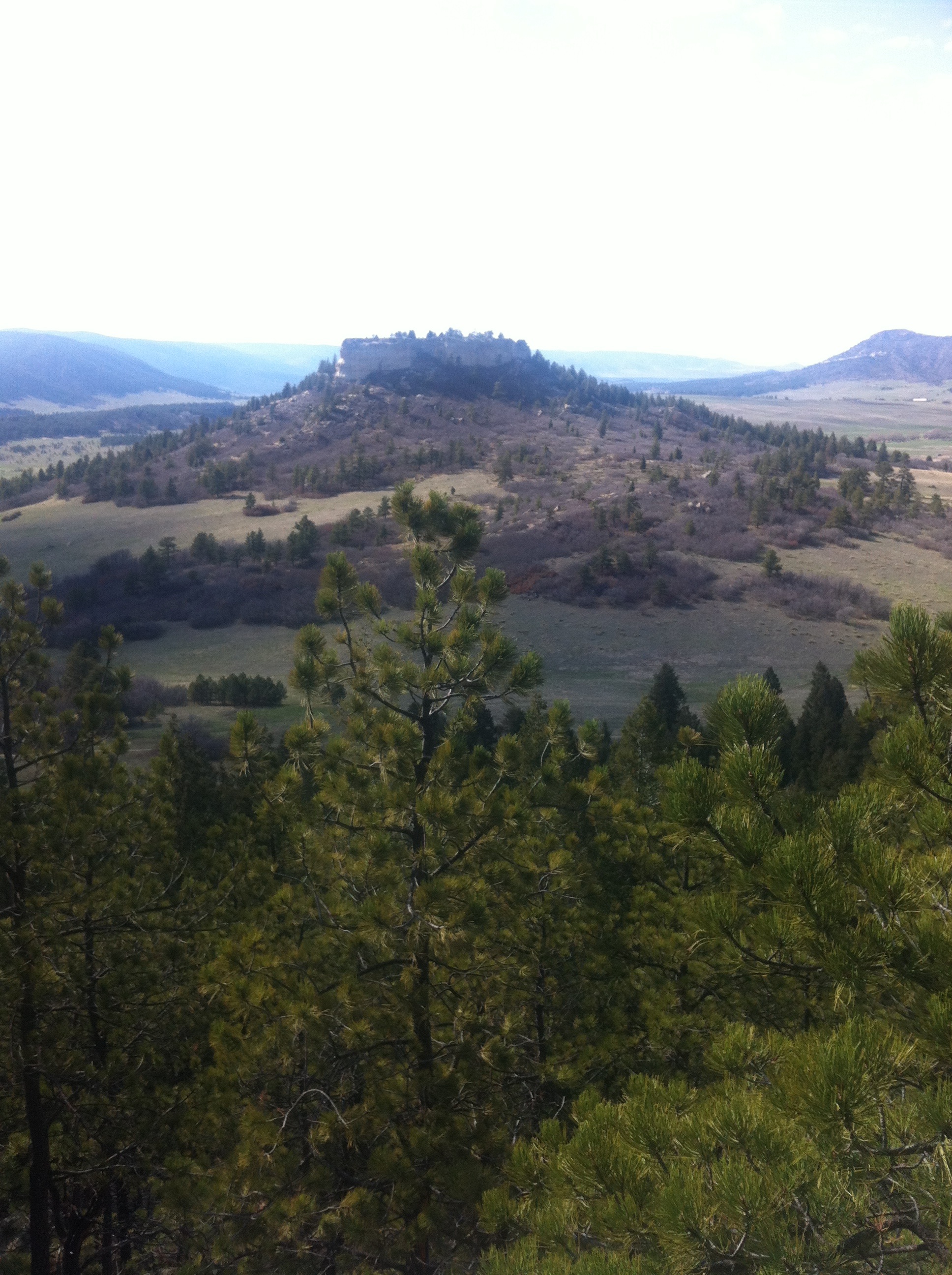 Why is that? There were plenty of spruce trees, which seem to be immune, but we also saw many pine trees. It could be that the beetle hasn’t made it to this area even though they seem to be everywhere in Colorado. One thing that makes this area different is that it gets a lot of moisture. The Palmer Divide seems to catch the most of every storm in the area. I wonder if moisture, or lack of it, drives the pine beetle devastation in the state.
—————————————————————-
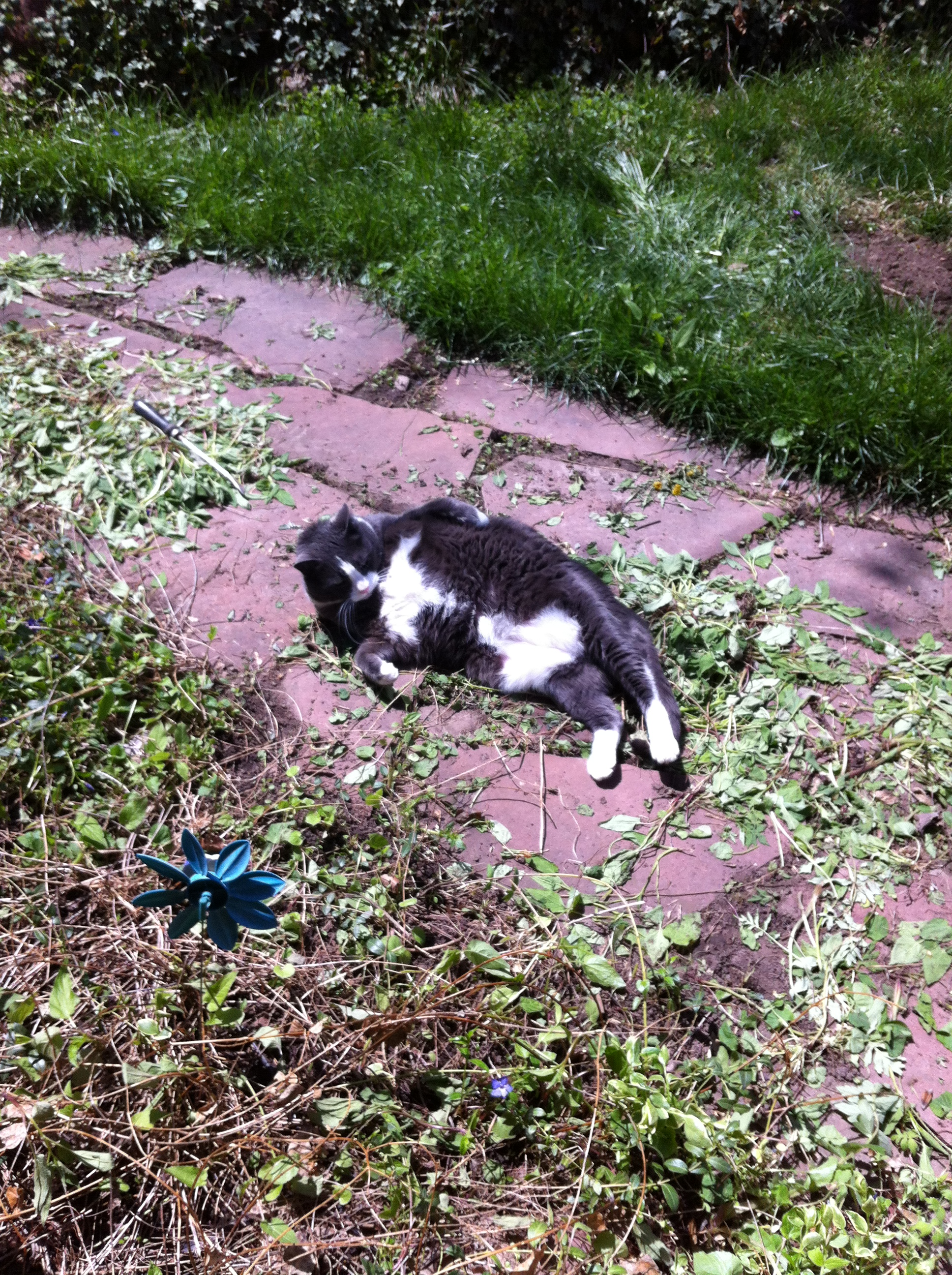
Also of interest: As I was leaving for a hike up Flagstaff last weekend, I spotted what may be the first confirmed sighting in modern times of a “sealcat” in Boulder. I was able to get a picture before it rolled away, shown at the top of this post. A sealcat is believed to be a cross between an elephant seal and a domesticated cat. They are dangerous at close distances but only move about as fast as a ground sloth. Like the North American river otter, this species hasn’t been seen in Boulder in a century! I have submitted this photo to the Colorado Division of Wildlife for analysis and possible confirmation.
Journal

Fracture Line of the Sheep Creek Avalanche
Jason Blevins wrote an interesting article about the Sheep Creek avalanche a couple of weeks ago near Loveland Pass. I’ve known Jason for several years, he’s interviewed me for articles about mountaineering accidents. His latest article talks about group dynamics and how it can play a role in making bad decisions. This is a very real phenomenon that is the root of many mountaineering accidents and I wrote about this extensively in Colorado 14er Disasters and Playing for Real. As for the recent avalanche disaster, I’m not so sure. The article doesn’t point to any specific evidence that group dynamics was the root cause of this accident, but it is certainly possible.
————————————————————————
Ok, this week had an unusual national news story about a big “brawl” on Mount Everest between Sherpas and some climbers. The basic story: A group of Sherpas were installing fixed climbing ropes high on an ice slope on Everest when three western climbers wanted to pass. The Sherpas told them to wait but the climbers decided to continue, allegedly knocking ice chunks down on the Sherpas. When the climbers returned to camp, a gang of Sherpas “…punched and kicked the climbers, [and] threw many rocks as well.” The climbers felt their lives were threatened and got the hell out of there, retreating all the way back down the mountain.
Though this news seems terribly shocking to the western world, it is completely expected to those who know the Sherpas and climbing culture in Nepal. I don’t mean the idealized and glorified image that one or two time visitors might see, I mean the actual culture that is only visible if you don’t close your eyes to it. I have had first hand experience with angry Sherpa mobs.
The first was in a very remote little mountain village called Tashigon in 1994. All expeditions to Makalu pass through Tashigon, an area where Sherpas are indigenous. They feel Makalu is their mountain and thus are entitled to take over porter duties, meaning the money, from whomever you had up to that point. Normally this means you pay off the lowland porters and hire these guys (for three times the price) and they get you to base camp. Well, some of the original porters wanted to continue with the expedition and after a big late-night rakshi-fueled party, the fighting started and the Tashigon-ers pulled knives and drove the original porters running out of town in the dark. Kind of like an inner-city street gang.
The second time was much more frightening. It was in 2003. We had just gotten back to Kathmandu after some peak climbs in the Everest region. Shelly and I wanted to move a bunch of gear from one storage facility to another and we recruited our lead Sherpa to help us. We flagged a little taxi and drove to the outskirts of town where our gear was stored and loaded it up. Just as we were about to leave a gang of Sherpas, who also helped us with our climb, showed up and an argument ensued. Our lead guy freaked out and jumped into the taxi and locked the door, telling us the gang that was gathering, growing to about 20 Sherpas, was going to kill him. I tried to get the taxi driver to leave but he walked away saying they would kill him if he tried to drive away.
This confrontation was the result of some incident that happened between the Sherpas weeks before during our expedition. Anyway, the gang opened the doors of the cab and were trying to drag our leader out. I pushed through the crown and tried to close the doors when a rock about the size of my fist cracked our guy in the face (note the “…threw many rocks” reference in the above story). Shelly tried to get the neighborhood’s attention by running down the road screaming for help while I jumped into the drivers seat and started to drive away. The taxi driver, seeing the blood and Shelly’s running scream, ran over to me and said he would drive us away.
Our guy wasn’t seriously hurt and to tell you the truth, Shelly and I were probably not in much personal danger. But it was freaky to witness this street-gang style revenge. To this day the Sherpas in our local Nepali restaurant called Sherpa’s remember this even though we never brought it up. Word spreads fast among this small ethnic tribe, even when they are half way around the world.
The point of this story isn’t that Sherpas are terrible people. They are quite the opposite actually, generally very happy in life and almost overly friendly. In the climbing/trekking world, Sherpas are viewed as almost super-human in strength of both body and character. But in reality, they are human beings.
Bottom line is this: Helping Everest climbers is a job for Sherpas and an extremely dangerous one at that. It pays well relative to other jobs Sherpas could do, but in comparison to western climber’s wealth, it is miniscule. The highest paid Sherpa on an Everest expedition might make $10,000 over the climbing season (the vast majority make less than $500) while a climber might pay six or seven times that amount just to make an attempt. Climbers are on Everest at their discretion and convenience. These guys who got “Sherpa-handled” on Everest are very well known in the high altitude community. Knowing these personality types, my first impression is the climbers ego got away from them and the Sherpas got pissed off, and it probably wasn’t a single event but the result of many smaller confrontations. No doubt there is more to the story we haven’t heard and probably never will, at least not on the national news.
————————————————————————
Wow, another foot of snow fell in Boulder on May 1! It’s been more like February than May this week. Another pic below, it’s hard to see exactly how deep in the photo but it’s about 8 inches. Four more inches fell after this.
Posted in Journal by Mark with comments disabled.
Journal

Sheep Creek Avalanche near Loveland Pass, CO (Dale Atkins)
A big avalanche accident happened on April 20 near Loveland Pass. The photo above, made by my friend Dale Atkins, an avalanche expert, shows the results of this humongous slide. Dale discusses avalanche accidents in my book Colorado 14er Disasters. This one was triggered by a group of 6 backcountry skiers and snowboarders, 5 of whom were killed. One survived after being buried for 4 hours, trapped in the cement-like debris with only his face and one arm free. He would have been buried even longer except that some highway workers saw the results of the slide and initiated the events that eventually lead to his rescue.
This was the deadliest avalanche in Colorado in 50 years. But even more notorious, this group was perhaps the most well prepared of any who venture into the backcountry to avoid or at least survive an avalanche. But they failed spectacularly. What happened?
Consider their preparation: They were part of a large organized group who met at the Loveland Ski Area parking lot to promote backcountry avalanche awareness. The group of 6 broke off to do a short downhill run, presumably to check out the snow conditions as well. Here are the facts:
- The group read and discussed the snow conditions report from the Colorado Avalanche Information Center (CAIC). It described a “deep, persistant slab,” meaning that there was a widespread weak layer of snow well below the upper consolidated layers. These weak layers are what make Colorado avalanches so dangerously unpredictable. Unless you know about them by studying the current snowpack and the CAIC reports, they are invisible. This group knew about the layer and decided to head toward what they thought would be a safer slope.
- When they got to the lower end of the Sheep Creek drainage, they spread out 50 feet apart to climb up the snow near the trees. This is exactly what they should have done in terrain that could avalanche, we did this all the time. The idea is that if an avalanche comes down it won’t catch everyone and there will be someone to dig up those who get caught.
- They were all wearing avalanche beacons, radio transceivers that allow you to be found if you are buried. Also, two were wearing avalungs and two were wearing avalanche airbags. The avalung is worn next to the body and helps you breath if buried in snow. The airbags help you ride on top of a slide. These are newer devices that help you survive if caught and are not very common. In other words, these guys were prepared for the worst.
- When the group triggered the avalanche, they were apparently in the runout zone, the relatively flat area below the gully. They heard a whumpf of the weak layer settling which caused a crack to run all the way to the top of the gulley. Minutes later the massive snowslide followed. Of particular note is that they were not on the steep slope but rather the flat area that itself could not avalanche. This is well known to be a danger zone, though the uneducated may feel safe here. Because the group was spread out, they apparently knew the danger.
They did everything “right” yet 5 are dead. As Dale Atkins has said many times, don’t let your equipment and training change affect your decision to go out on a risky slope. If the slope is dangerous, nothing you know or wear will change that. It’s best just to avoid the slope, come back on another day.
———————————————-
Saturday was the first spring-like weekend day around here in a while and the hiking trails around Boulder were overwhelmed by people, far too many for me. I wasn’t into doing any backcountry skiing on such a nice day and the snow line is still pretty low, so I wanted to hike around the foothills where it wouldn’t be muddy but get away from the masses. I hadn’t been down to Green Mountain, which is located on the western edge of Lakewood, for a long time and so decided to visit.
This is where we used to teach map and compass navigation to students in the Colorado Mountain Club mountaineering school. That was many years ago and wow have things changed since then. There are nice, signed and maintained trails all over the mountain, plus several new parking lots. Though there were always trails everywhere, they were rustic with no signage. It’s kind of cool that Jefferson County has taken an active role in managing this park. It’s a large area too, I did a 7.5 mile circuit shown by my GPS track below right.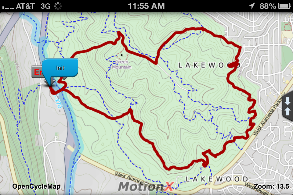
Unfortunately, it is located just east of the 8-lane C-470, a commercial race track and a dirt bike track. These three combine to make it impossible to escape engine noise which is audible in almost every area of Green Mountain. Oh well, not everywhere can be like Boulder open space…:-)
Still, if I lived in the area I would be very grateful for this park. Any green space is good, especially near urban centers. In 2006 I visited Taipei on a business trip, a huge city with a massive population. It took at least an hour to taxi from the airport to my hotel through nothing but buildings, concrete and asphalt. I was pleasantly surprised to find a mountain park near my hotel, a tropical forest-covered hill surrounded by skyscrapers. It was a great escape from the crowds and artificial environment, if only for a little while.
I have to say that a big issue that needs to be dealt with in open space are careless users. It is far too easy for urban parks and open space areas to become trashed out and dangerous places. In my opinion, only active and aggressive management can prevent them from becoming a tragedy of the commons. It only takes a very few bad actors, who will always be around, to begin the trashing cycle. Without money, volunteers and rangers these urban interface parks become undesirable or even unusable.
———————————————-
I was in Oregon last week during the last major snowfall here. It was 70 degrees under cloudless blue skies. It was one of those rare occasions that the weather was better in Portland than it was here. While there I heard several news stories about Dustin Self, the guy who disappeared in the south central Oregon wilderness last month. The stories were about alleged sightings of Dustin around Oregon and that they would not continue to look for him until conditions “improved.” They’re waiting for the snow to melt.
Posted in Journal by Mark with comments disabled.
Missing in the Wilderness

Steens Mountain Wilderness in Oregon, where Dustin Self is presumed missing
Today this story about Dustin Self of Oklahoma City caught my attention. He went missing about a month ago and his abandoned truck was recently found near Steens Mountain, a remote wilderness area in southeast Oregon. Another story is here.
These are the apparent facts: Dustin Self drove from Oklahoma City to Oregon. He was last heard from about a month ago when he made a call to his ex-girlfriend saying that he was lost. His ex called the authorities in Oregon and they did some investigation and find out he was last seen in the small community of Fields, Oregon, where he asked directions to Lakeview, a town about a hundred miles west of Fields. There were no other signs of Self until Monday when his truck was found by a rancher. It was located about 500 feet down a ravine, in the desert on the east side of Steens Mountain, which is about 25 miles north of Fields. Self was not in the truck and there were no reported clues as to where he is. The search was postponed due to high winds in the area yesterday.
The background story is this: An Oklahoma teen tells his parents he is “going off the grid” for a few months and drives to Oregon. He wants to live off the land and investigate a religious group that drinks South American hallucinogenic tea in its ceremonies. He is reportedly a big fan of Into the Wild. He had broken up with his girlfriend the day before he left Oklahoma.
This is another interesting mystery of disappearing in the wilderness. What really happened we don’t know yet but I can’t help but notice the similarities between Self and Winston Branko Churchill, who I wrote about in Forty Demons. Like Winston and Chris McCandless from Into the Wild, Self apparently had a love of the wilderness and was seeking a more intense connection. And like Winston, Self seemed to have an interest in Ayahuasca, the South American hallucinogenic tea mentioned in the articles.
But to be frank, media reports on stories like this are notoriously inaccurate. If you read the two articles I linked to at the beginning of this post, you’ll notice that when they mention Self’s outdoor survival experience, one article spins it to give an impression he is a complete novice while the other one gives the impression that he is well equipped and ready to survive anything. Which is it? Also, he is described as a “teen,” which I guess is technically accurate but in reality he is a 19-year-old man. I and my friends went on many true wilderness adventures at this age and younger.
Also, if Self were trying to drive from Fields to Lakeview, he was way, way off track based on where his truck was found. There are many possibilities for this other than being lost. He may have been intending to disappear, as one report stated. Or he may have had an accident, got stuck and tried to walk out and became lost. Or he may have been the victim of foul play. We don’t know and may never know. Even after Winston’s body was found near a remote cabin in the Uncompahgre Wilderness, it took significant investigation to understand what might have been going on in his head during his last month of life.
Or Dustin Self may walk out and have a great story to tell. Only time can tell.
Posted in 40 Demons Archive, Journal by Mark with comments disabled.
Journal
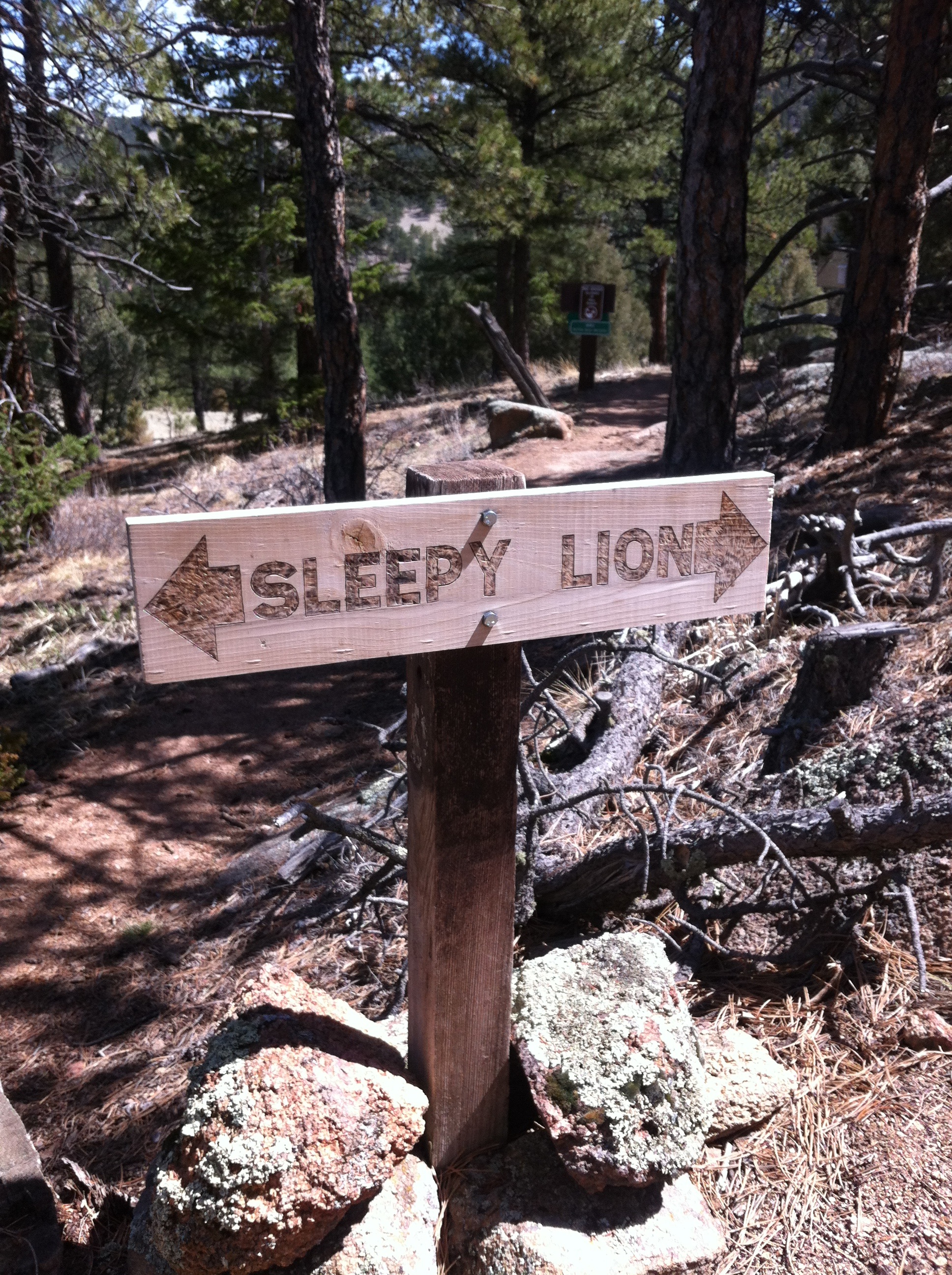
Sleepy Lion Trail Sign
Ok, last weekend was kind of lazy but I did a couple of short hikes near home. Saturday was beautiful and it seemed all of Boulder was outside in the foothills. I decided to hike up to the Third Flatiron. One great thing about living in Boulder, and one of the reasons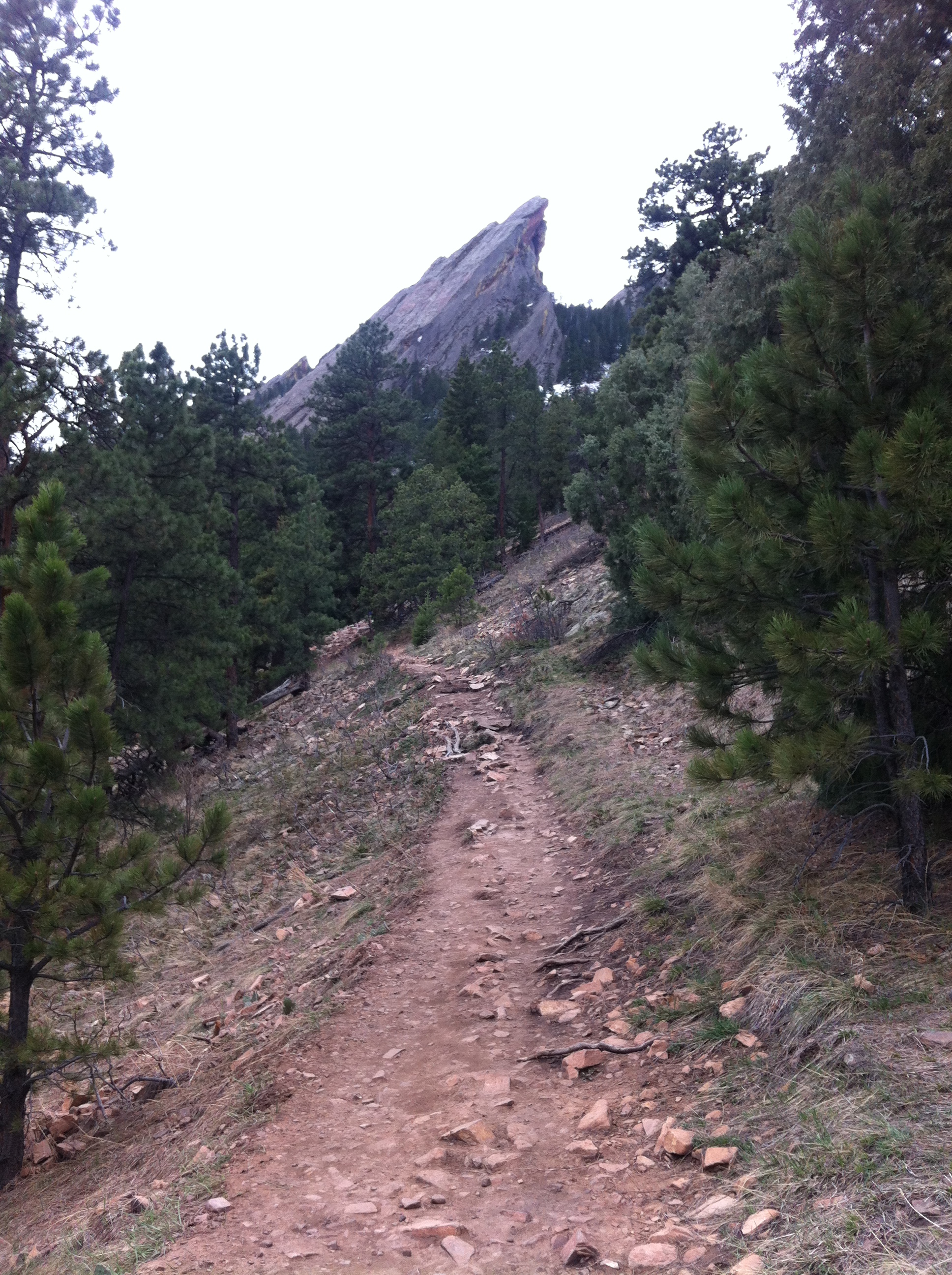 we moved here, is that we can get into the mountains from our front door. No driving necessary. Not only that, no parking necessary. On nice days and just about all summer long, you can’t park within a half mile of Chautauqua Park if you don’t get there at dawn. The area receives some millions of visits per year, more than Rocky Mountain National Park. Our house is about a 10 minute walk from the park, which is cool. We’re also about a 10 minute walk the opposite way from the west end of Pearl Street and about 10 minutes from The Hill and CU. We’ve saved millions of dollars in parking fees over the years, minus $25. The “minus $25” was for a CU parking ticket I got a couple of weeks ago. Go figure.
Anyway, on Saturday I hiked up to “The Third,” meaning the Third Flatiron. Actually, you can only get as far as the wildlife closure. They keep people, mainly climbers, away from the Third Feburary-July so that nesting raptors won’t be disturbed.
 Sunday was different. The weather had turned ugly. What I mean by that is probably not what you think. It was clear and bright, no snow or rain. But the temperature was just above freezing and the wind had picked up. That combination of cold and wind makes hiking quite uncomfortable. Why? Because it’s really not cold enough to wear heavy clothing like you might do in the depths of winter, you get too hot from the work you’re doing. On the other hand, the wind really cuts any exposed skin so you need to cover everything to keep from freezing yet ventilate to keep from overheating. You end up in a constant battle of clothing adjustment. On top of that, when the wind gets that high it is just plain annoying!
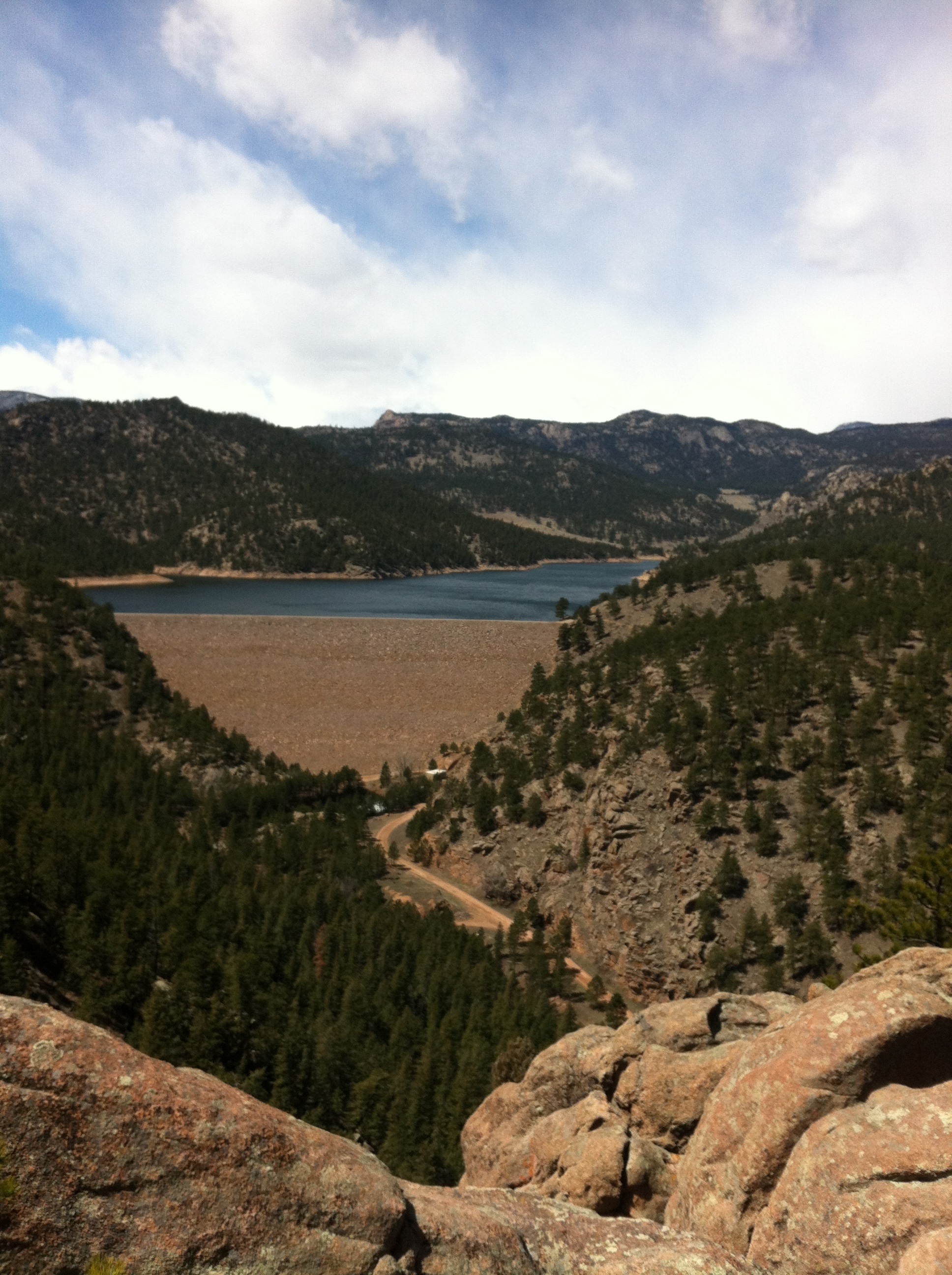
But I needed a workout so I went up to the Sleepy Lion trail just west of Lyons, CO, our old home town. It’s a fun, scenic loop that takes you into the forest for a view of Button Rock dam, right. GPS track is above left. You start out by walking down an access road for about a mile and then get into the forest trail. The trail takes you up and soon you get a view of the dam and reservoir below. On a perfectly clear day you can see Longs Peak in the distance, but not on Sunday. No, the wind was blowing over the divide, producing orographic snow and clouds to obscure the view.
The trail continues to the base of the dam and back out on the road you can see in the photo. I was surprised how popular this area had become and how many people were out on the trail even on this cold and windy day.
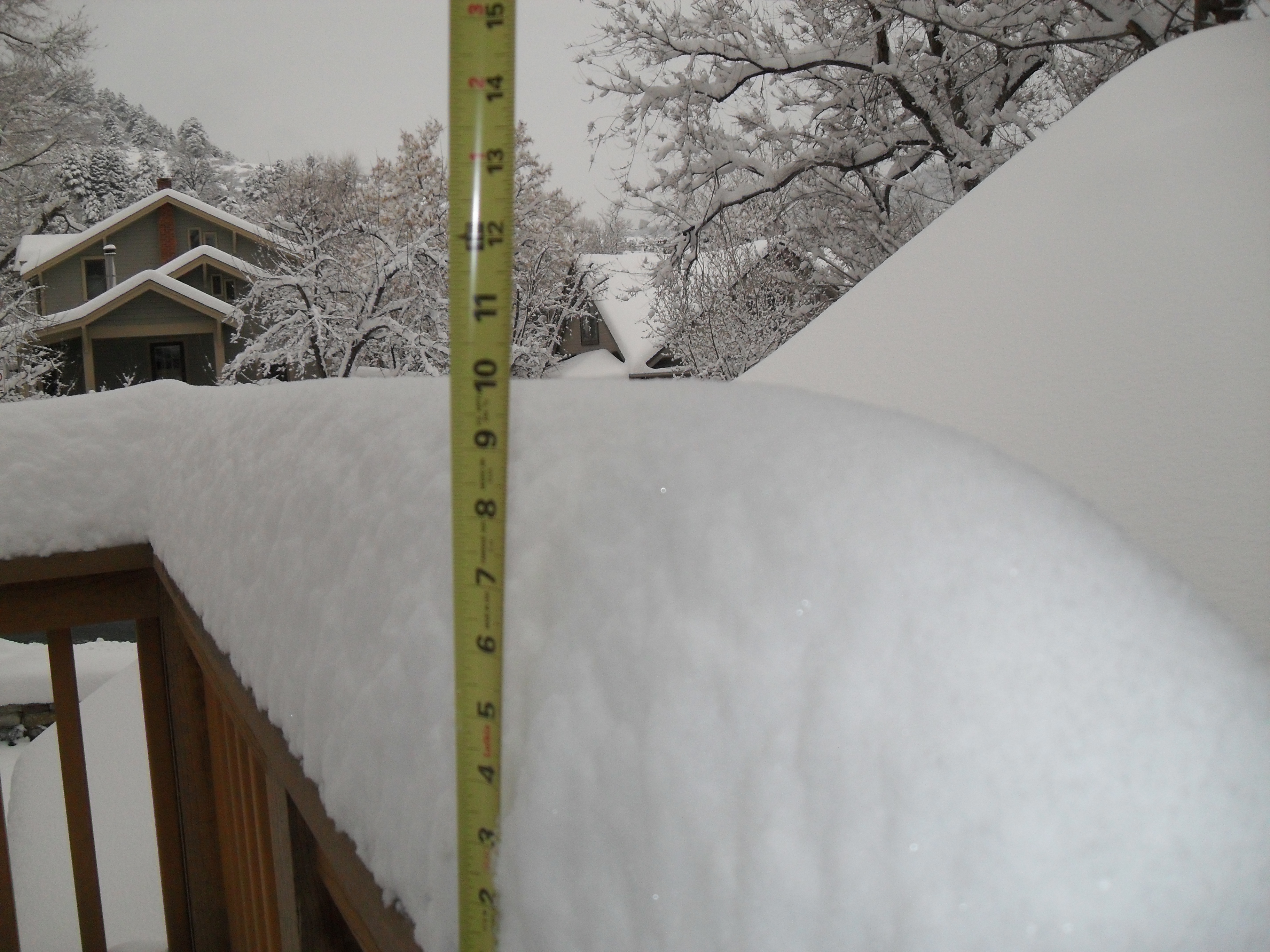
Another Tuesday, another foot of new snow at our house (see pic at the end)… Well, it measures slightly less than a foot but this is after consolidation overnight. Last week’s foot of new snow was very dry and powdery and completely melted away by the weekend. Yesterday’s snow was good and wet. If it doesn’t warm up really fast, and it’s looking like it might not, this snow could last a while. It seems to me the largest cause of our current drought is that it has been so warm in the spring. Last year it felt like we shifted from winter directly to mid-summer in March. The big spring runoffs happened more than a month early and the summer continued to be way too hot. This year is shaping up to be like a “normal” spring so far. We’ll see.
Posted in Journal by Mark with comments disabled.
Hogan Park: The Carry Emergency Survival Gear Ski Tour!
 Dire Warnings to the Unprepared!
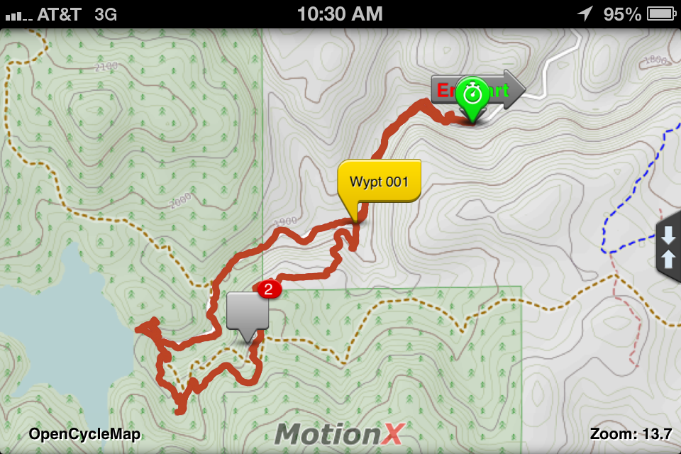
Ok, I’ve been too busy to post earlier this week but here is the latest. Last weekend we did the long Hogan Park backcountry ski tour near Steamboat. The trip starts at the Walton Peak parking area on Rabbit Ears pass and ends at the base of the Steamboat downhill ski area. It’s seven miles of mild up and down touring through the pine and aspen forest that ends at the base of the Morningside ski lift. From there you ride the lift up (the resort lets you ride once for free) and do the long downhill run to the base area. We then hired a taxi to take us back up to get our car at the top of the pass. Overall, the tour took about 6 hours. Click on the map below for a detailed view of our route.
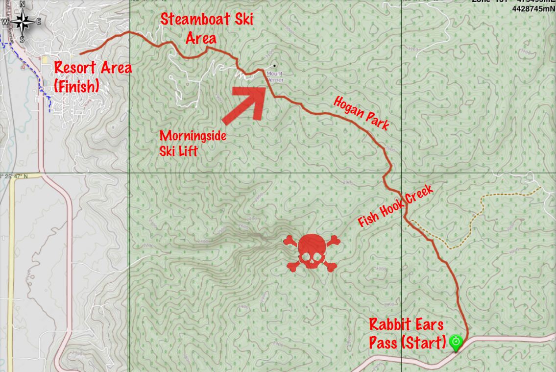
The map shows the GPS track of the route. I used MotionX GPS app on my iPhone and it worked great. The cool thing about this particular app is that it allows you to download maps for use in the backcountry where you probably won’t see a cell site. Google, Bing and Apple don’t allow you to download maps, you need a cell or wifi connection to use their mapping applications.
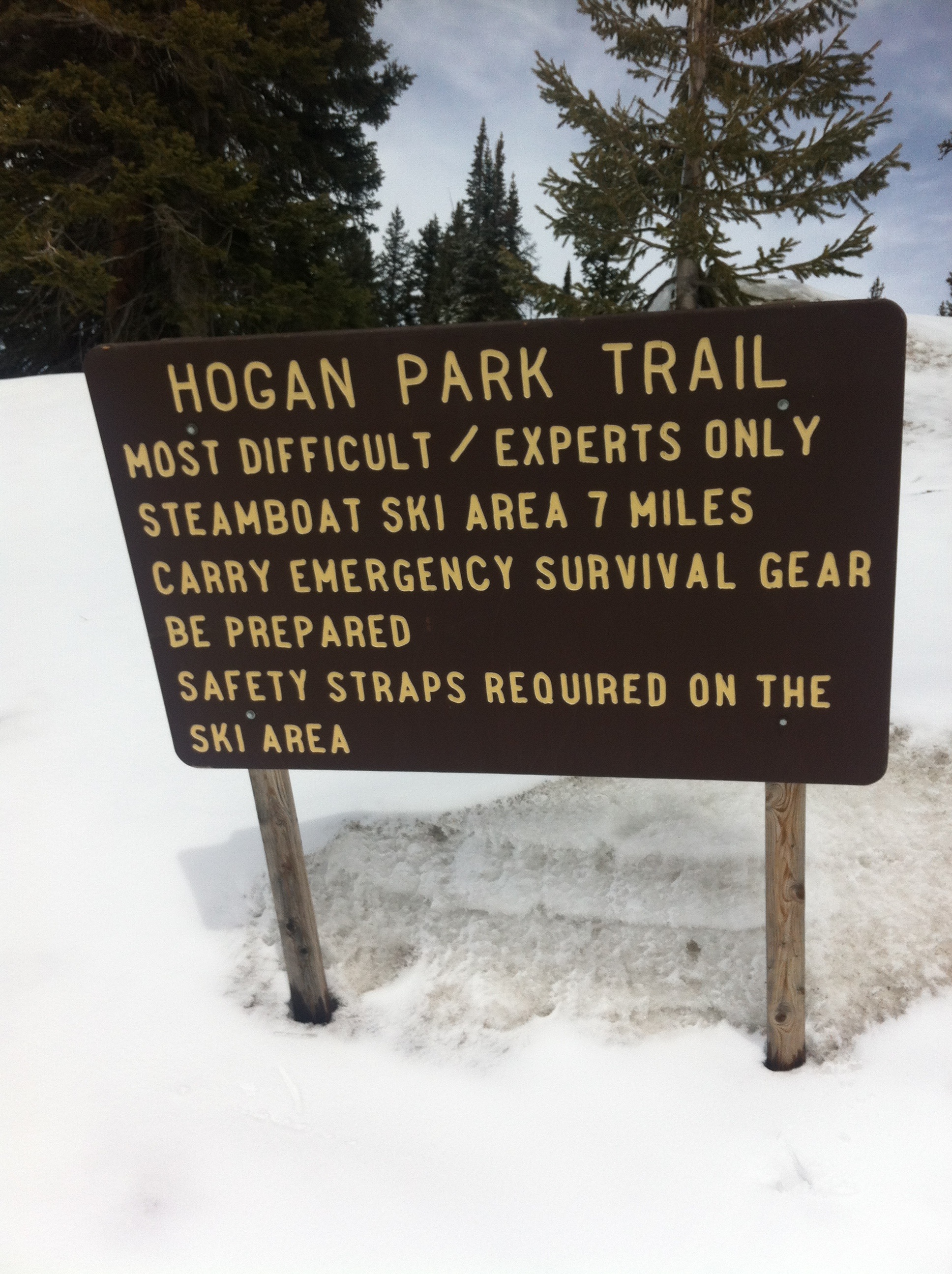
The map shows the area just to the southeast of Steamboat Springs. The resort area is in the upper left corner of the map. The downtown area of Steamboat is slightly off the map to the northwest. I labeled some of the interesting spots. The tour starts at the bottom right where you see the highway at the top of the pass. The first thing you see is the sign pictured at the start of this post warning that this is for “experts only!”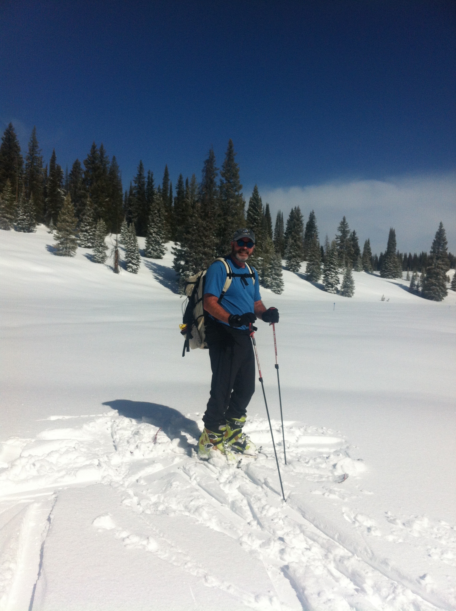
To me this kind of warning is a little over the top. It’s probably necessary though, given the nature of this route. I’m not sure you need to be an expert, but you certainly must take more care than the casual skier might. It’s not even close to difficult in terms of physical difficulty. There aren’t any super-steep or long climbs on the route, and it really isn’t that long. But those aren’t the only aspects to consider when in the mountain wilderness. The route is marked about every 50 feet by blue diamond signs, either nailed to trees or poles in the open field. Seems easy to follow, but the real difficulty here is navigation.
Several conditions combine in this area to make navigation tough. If you miss a blue diamond route marker, you have very little to help you with dead reckoning. Why? First is the “flatness” of the area. There just aren’t many visible landmarks to orient yourself. There is no overarching mountain visible like there is in most areas of Colorado. Also, the terrain seems to repeat itself as you wander: Hills covered with trees separated by wide open meadows, followed by the same.
 Add to this the notorious Rabbit Ears weather: Whiteouts seem to be much more common here than anywhere I’ve been in the state due to fog and snowfall. And it snows here more than you might expect. This tends to cover any tracks from previous skiers that you might follow. See the pics on the left and above right, the only tracks you can see were made by us.
The skull and crossbones on the map indicates the area where some lost skiers get into trouble. If you turn west too soon you run into an impossibly steep canyon. Skiers have gotten stuck, waited a freezing overnight and subsequently rescued in this impassible terrain. The reality is, navigation is not difficult, especially with the tools available today. You just have to be disciplined enough to do it. 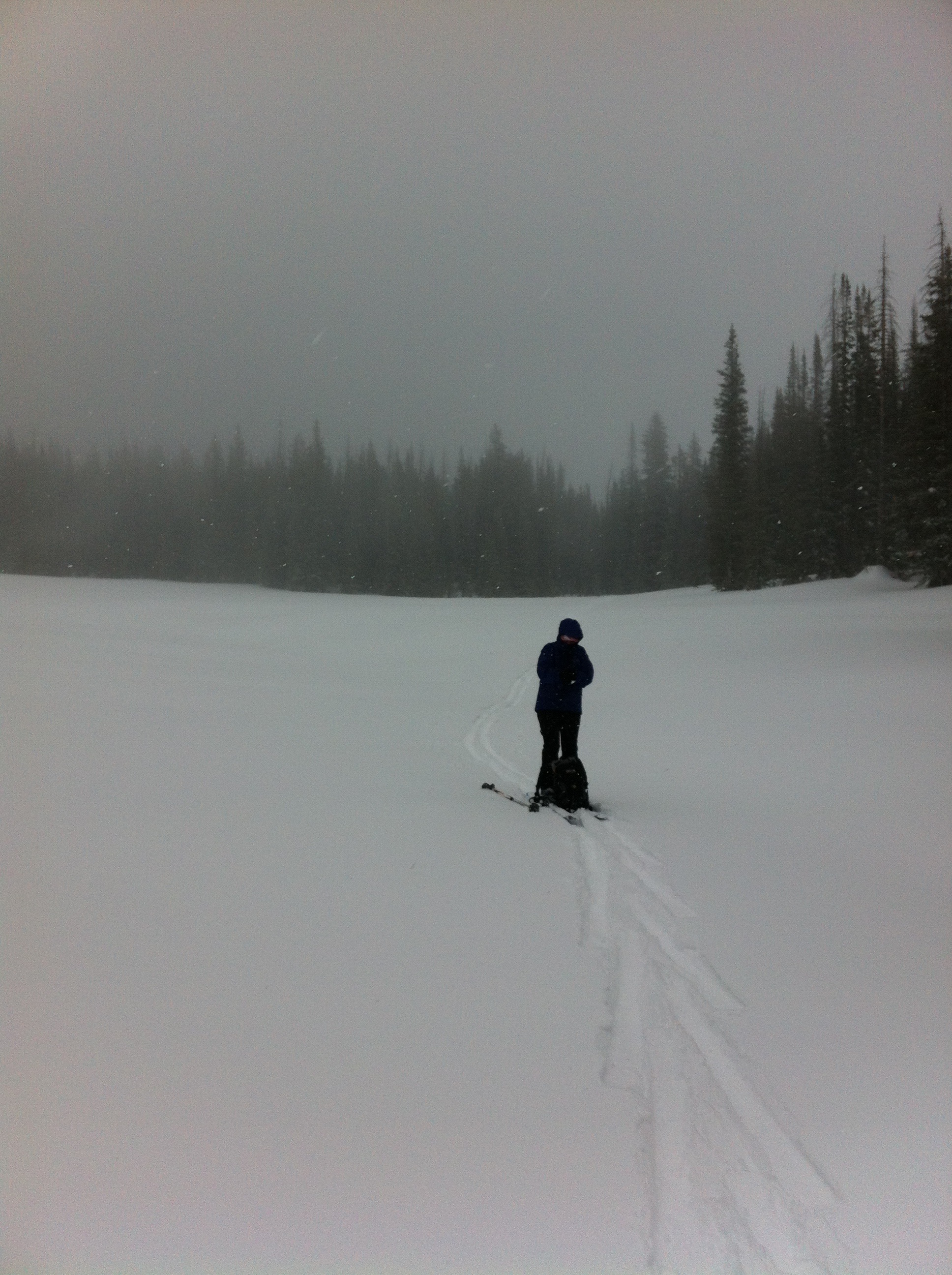
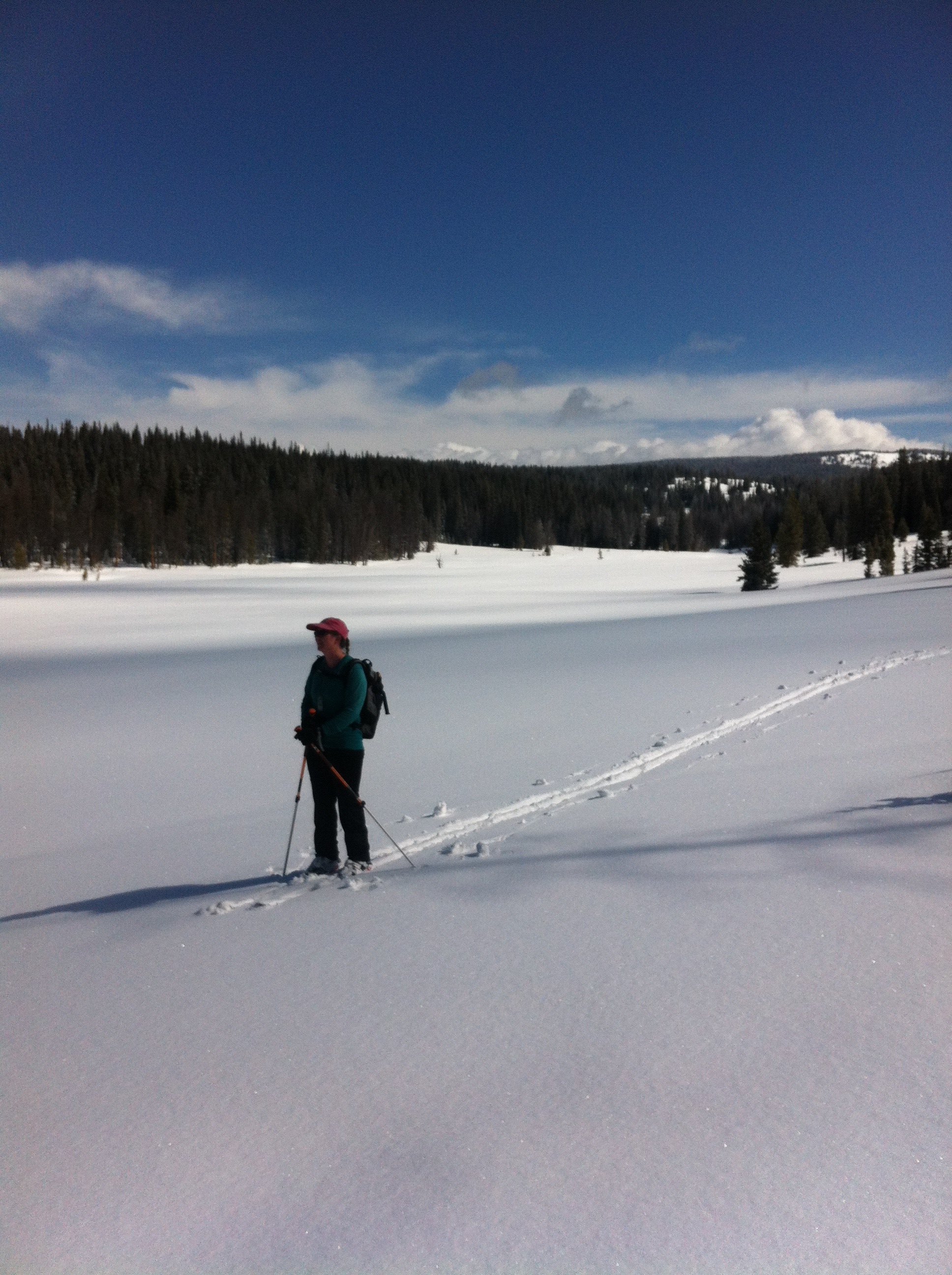
Shelly had her compass out and checked our direction the entire time. Also, if we hadn’t seen a blue diamond marker in a while we would retrace our steps to get on route. Best of all, the GPS app indicated exactly where we were at all times. In combination with a Trails Illustrated map that plotted the route, we could quite easily determine our position. On top of that, we actually did confirm our position periodically.
There was no one else out there and breaking trail the entire way made this feel like a long haul. A “long haul” falls somewhere between a “good day” and a “death march.” As we got to the Hogan Park area, a mile and a half long open meadow, the weather started to deteriorate until we were in a full-on blizzard, as seen on the right. By the way, click or tap on any picture to see a large version of it.
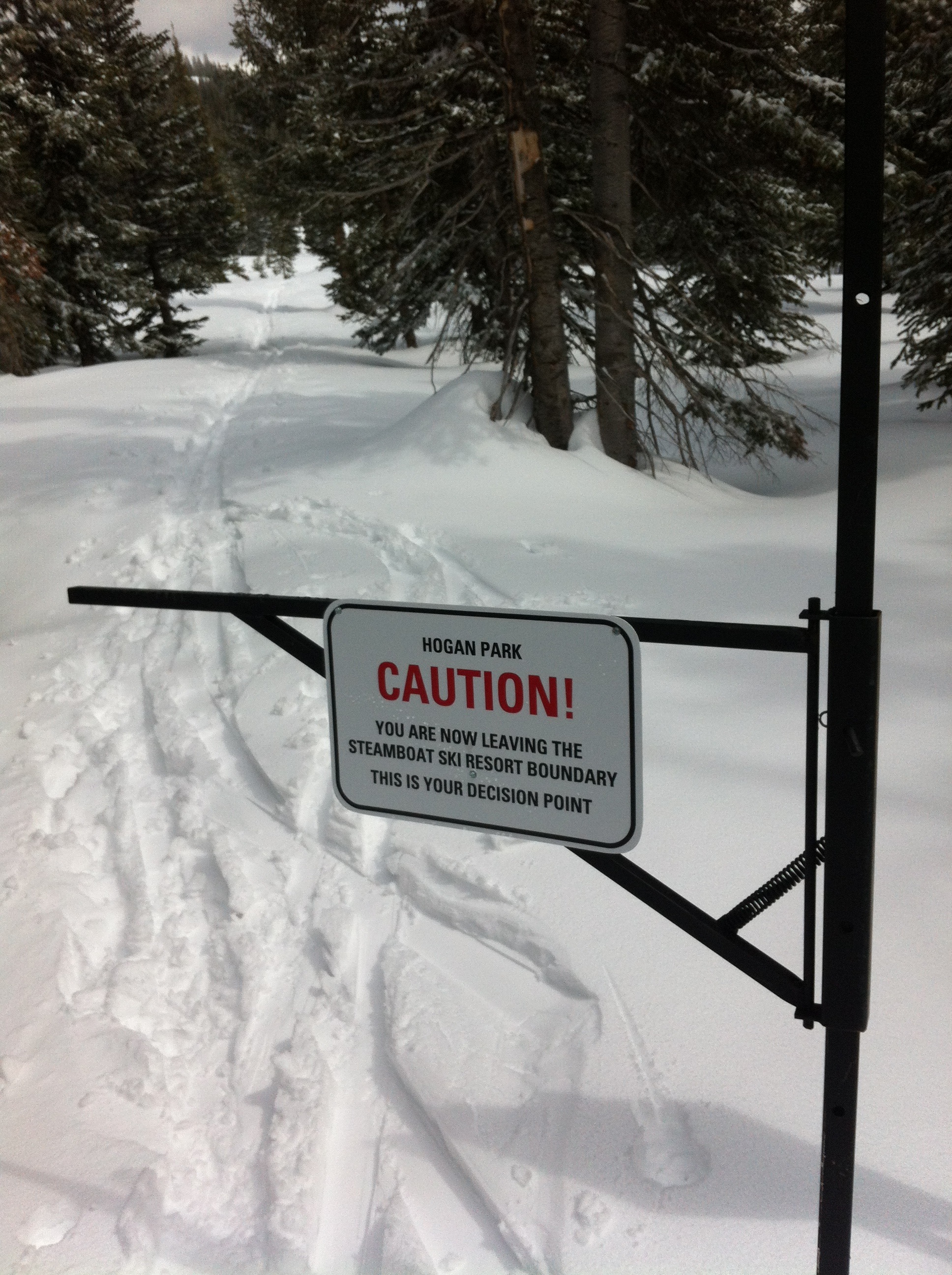 Anyway, after about four and a half hours we finally arrived at the outermost point of the Steamboat ski area. Yeah! The most difficult part was done. The ski area is roped and fenced in. This is meant to keep customers inside the area, not to keep us out. But there was an actual gate we needed to get through. Looking back, we read the sign on the left. The Ski Patrol does not want people to leave the area because this can cause them big headaches. If a customer goes missing, the Ski Patrol has to start searching for them at the end of the day. It’s always somewhat surprising that a sign needs to be put up warning you of your “decision point” to enter the forest, but there it is.
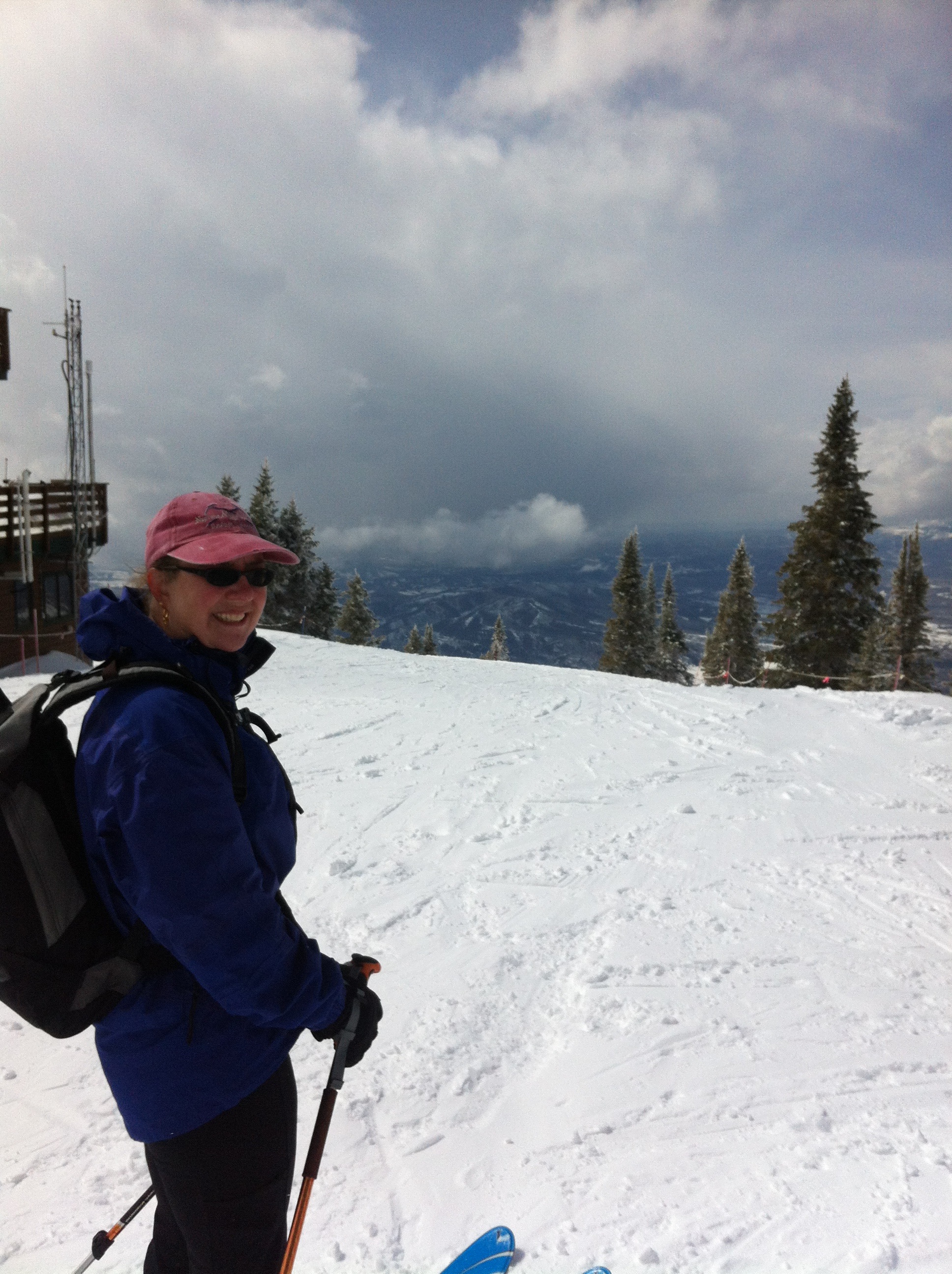
Anyway, the Morningside lift is right there. We adjusted our skis from touring mode to downhill mode and got on the lift. The operator asked how the trail was as we boarded. He could tell by our packs and lack of lift tickets that we were not downhillers but super-cool backcountry adventurers.
You might think at this point, with skiing down to the base being the only thing remaining, that navigation was over. You would be wrong. At the top of the lift, pictured on right, you are as far from the base as you can be within the ski area, and you have miles to go. There are several “dead ends” that force you to ride another lift to get out. Feeling shagged, we wanted to make this part as short as possible. In other words, navigation through the ski area is desired.
 It’s not quite the same difficulty, of course. We did this route a couple of years ago and it was the first time we had skied the downhill area. Last weekend was the second time. It is a huge and most excellent ski resort. We’ve owned our place in Steamboat for almost five years and have yet to buy a lift ticket. Funny how that works out, but really there are so many other skiing opportunities in the area and the lift tickets are very expensive with no chance of getting a discount.
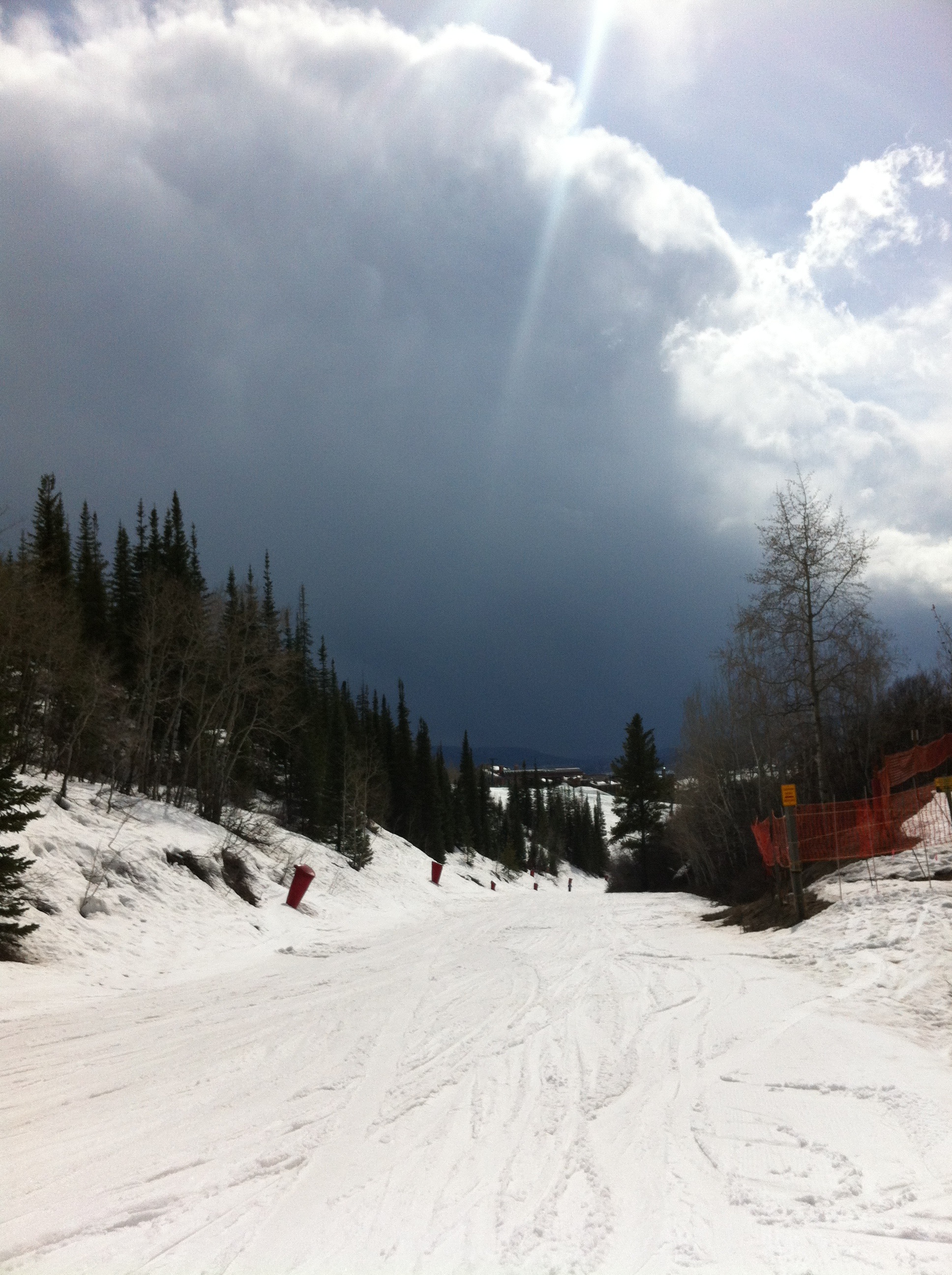
It takes a long time to ski down, especially if you quads are already burnt out. The snow at the top was fantastic but near the bottom it was thin slush. A big storm cloud loomed on the horizon, as you can see on the left. It looked like a summer thunderstorm.
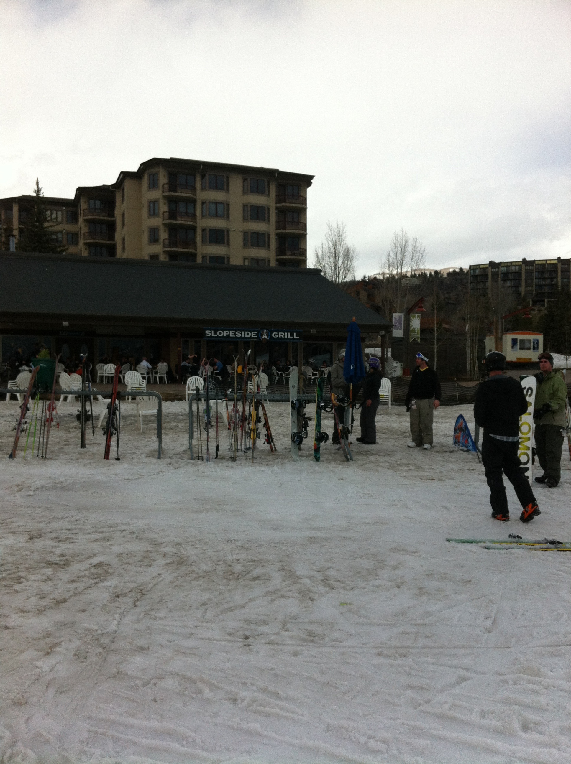
Finally at the end, we found the “pub at the end of the rainbow,” the Slopeside Grill. We stopped in for a celebratory beer… NOT! Unfortunately we still had to get the car from the pass! No problem, the beer could wait.
Posted in Trip Reports by Mark with comments disabled.
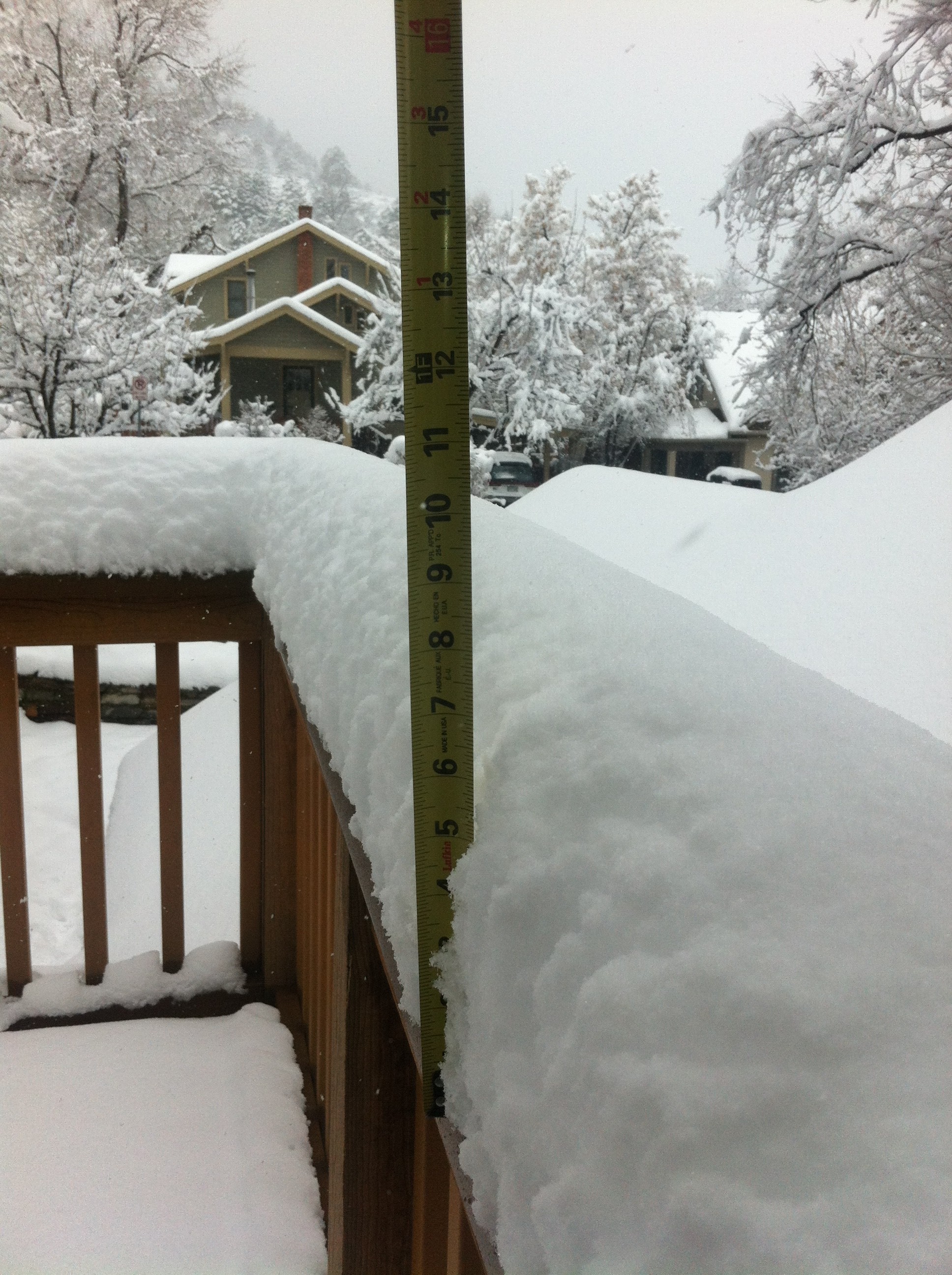
Spring Snow in Boulder!
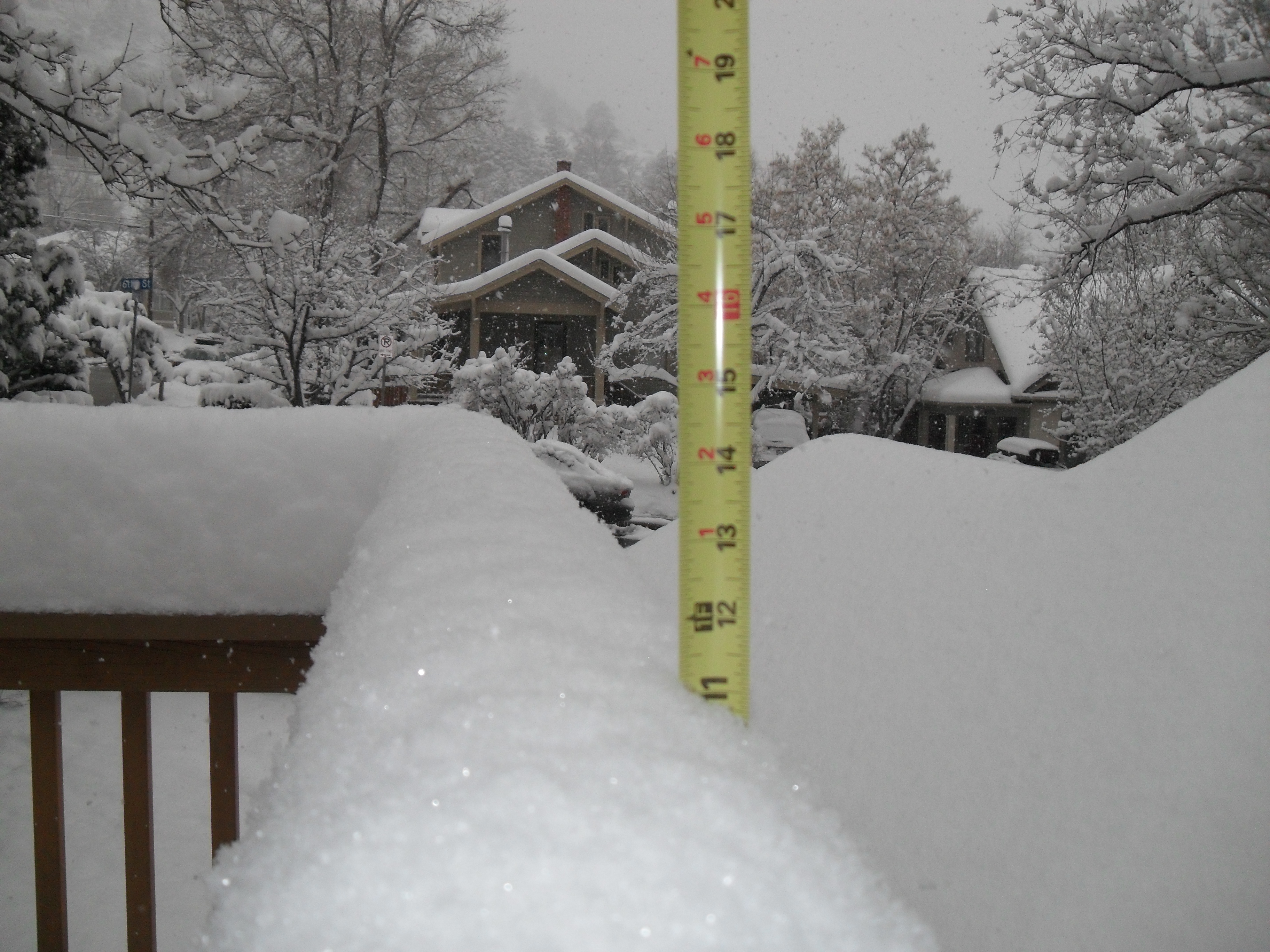 The spring snowstorm that started last night has left a foot of snow in western Boulder by 5 pm and it’s still snowing. Click on the picture to see proof!
Posted in Journal by Mark with comments disabled.