December in St. Augustine
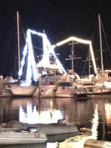
Bright Holiday Lights On Big Boats
Sunny, and windy, St. Augustine is well known for their holiday lights this time of year. Both Shelly and I thought it felt weird to have a Christmas season in such a tropical-feeling town. We are used to cold, snow and much longer nights of a “real” winter holiday. We are happy to be nice and warm here.
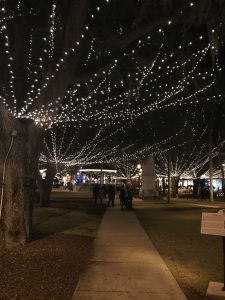
Downtown At Night
We did a walking tour of the city and got several Uber rides to do our shopping. Uber has been fantastic so far, everything has worked out much better than expected.
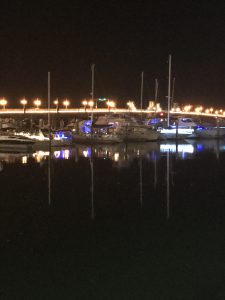
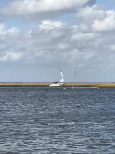
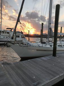
Light-Decorated Lions Bridge and Sailboats at Night
Yesterday we were visited by a friend from many decades back, Tom, and his wife Beth. Tom is a wildly successful neuroscience professor at the University of Florida who has taken up a sailing hobby in the last few years. We had a lot to talk about, the old days and the new days sailing.
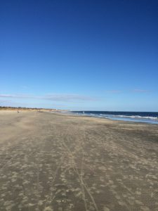
Today we were visited by another old friend from the same era, Roxanne and her offspring Jack. Went to a wine tasting and then walked along Anastasia Beach at sunset. It was great to see these two old friends after so long and reconnect.
We have a few more days rest here. Plans are in flux. Where will we be over the winter? Tune in to find out!
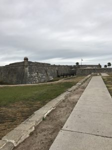
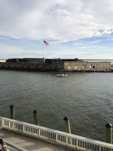
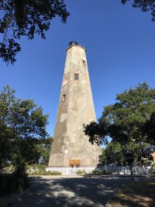
The Old Spanish Fort Castillo de St. Marcos
Posted in Sailing by Mark with 1 comment.
ICW Mile 780: St. Augustine, Florida
Ship Graveyard
We arrived at St. Augustine today after two nerve-wracking days down the ICW from Cumberland Island. The weather has been unsettled so we decided to stay “inside”. Yesterday we timed our departure to traverse the route near low tide because we heard the bridges were “low” for 65 feet. We moved out of our anchorage at a fast clip as we were going with the tide, but after about an hour we were fighting the current and moving at a snail’s pace.
Passing Fernandina Beach we started noticing all the damage from hurricane Matthew. The pic above shows what looked like a relatively new boat wreck, we thought from the hurricane. In the foreground are masts from a much older wreck sticking out of the water. Apparently this is where many boats go to die.
Most of the docks along the 65-mile stretch between Cumberland and St. Augustine were trashed. There were several large but empty marinas along the way. But this was not our main problem. The tide in this area is extreme and so are the currents.
As I mentioned, we spent the entire day yesterday moving at low tide and we ran into problems with shallow water. As sunset was approaching, we were within ten minutes of our dock when a motorboat passed us. Shelly politely steered to the right to give them room but their wake knocked us into the shallows and we grounded out. We were stuck! A primary rule on the ICW: Never, never, never move over for someone to pass, let them go around you. We knew that but being good guys we were trying to be nice…
We knew the tide would lift us off at some point, so we waited. I had almost no patience after the long day and being so close to our endpoint, but there was nothing to be done. After about 30 minutes Shelly noticed that our bow had moved and maybe we could back out of the mud. We tried it and it worked! Shelly the genius!
We grounded out two more times just after that but were able to immediately pull ourselves off. We finally got to the free dock outside Jacksonville and there was one tight space left. Fortunately for us there were about five people there to help get us into place, we couldn’t have squeezed onto the dock otherwise. One of the great things about the cruising community, lots of help from those who have been in the same situation as you.
We planned to go at high tide today, and though passing under no less than 7 bridges we had zero problems with our mast or with shallow water. The current was of a challenge, but much easier overall than the day before. Bottom line, sailing in the ocean is much better for Good Karma!
We are hanging out here for a week to rest and visit friends. More later!
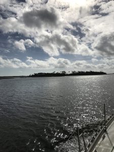
Summer-Like Clouds Near St. Augustine
Cumberland Island, Georgia
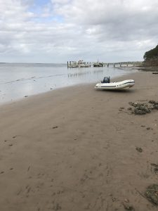
Our Dinghy “Namaste” High and Dry
We tried to get into Cumberland Island yesterday but the waves were too rough. Sandra Fish advised us that we really needed to visit the island so we came in today. It was last owned by Thomas Carnegie, brother to the famous and wealthy Andrew, and is now a National Park.
We couldn’t go into the dock due to hurricane Matthew damage and so took our dinghy Namaste into the shoreline and struggled to find out how to tilt the engine out of the water. Shelly said we looked like Laurel and Hardy to anyone watching, and she was right. We maneuvered her to a tie-in and headed in to walk along the trails. Walked to Dungeness Beach on the Atlantic, below:
Dungeness Beach
We neglected to pack a lunch and so were starving at this point. We made a beeline back toward our dinghy and came across several armadillos.
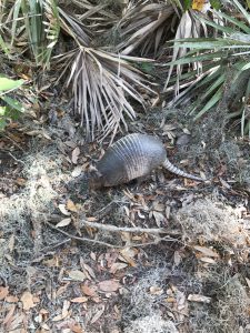
South Georgia Armadillo
It is quite strange to us to see animals such as these. We are Colorado natives and never deal with such strange animals. They are like moles or something and hardly care about you passing them.
When we got back to Namaste it was low tide and so we had to drag her 300 pounds about 100 feet back to the water. It was not an easy task, but necessary if we were to get back to Good Karma. Later that evening we visited Jim and Cynthia on their sailboat Neverland for happy hour. We learned a lot from them about boat life, both good and bad.
Tomorrow we head toward Jacksonville.
Posted in Sailing by Mark with comments disabled.
ICW Mile 714: St. Marys River Inlet, Florida
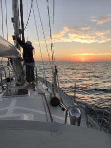
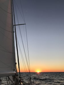
Shelly Prepping the Mainsail Halyard at Sunset While Underway
This afternoon we completed our longest passage yet and made it all the way to Florida! Well, actually we aren’t technically anchored in Fla. tonight, but just over the border in Georgia. We completed a 160 mile offshore passage between Charleston and St. Marys River inlet, the border between Georgia and Florida. Had we turned left at the inlet we would be anchored in Florida, but instead we turned right and anchored in a more promising spot in Georgia.
Our 30-hour passage allowed us to shortcut 250+ miles of some of the more difficult ICW sections in Georgia due to it’s winding path, large tidal changes (up to 9 feet), hurricane damaged marinas and high currents (in addition to the ubiquitous ICW bridges, traffic, etc.). One guy warned us that you would travel for an entire day in the Georgia ICW and end up only a stone’s throw away from where you started that morning because of the winding nature of the route here. We’re glad to miss that part.
Last night’s sail was a bit different in that we were crossing several busy shipping channels. We had to maneuver a couple of times in the darkness to avoid thousand-foot long ships entering or leaving the Savannah River. Our course kept us at least 30 miles from the actual channel but many ships arrived or departed in the night to all points on the compass, two of which crossed our paths within a mile. AIS is invaluable, though we could at least see the lights on these juggernaughts.
As seems to be the usual case, the most difficult time was at about 3:30 a.m. when the wind shifted and intensified, gusting to over 20 knots. I’ve discovered that when the wind starts to whistle through the wires of Good Karma, it is blowing greater than 18 knots and it’s probably time to make adjustments. I was trying to manage everything on my own so that Shelly could sleep (it was only her second hour of sleep that night) and was successful. We are both getting much better at single-handing the boat though we have made a few safety rules about actions we will not do alone, one of which is to go forward out of the cockpit (especially at night) without a tie-in or the other of us monitoring for problems.
I have been titling the posts for this section of the blog as ICW mile marks though we really haven’t been in the ICW for the last 410 miles. And why should we be? This is a blue water sailboat, made for sailing in the ocean, not traversing these freakin’ canals! Yesterday we saw so many dolphins we lost count and when we’re able to sail on a good wind it is smooth and peaceful. We’re pretty happy to be out of the ICW and getting our first taste of overnight passages, though it has been exhausting. As with anything new, the more we learn and experience, the easier it becomes.
One of the best lessons on these long overnight passages is that Good Karma is one hell of a sailboat. Tough, sturdy, sleek and maneuverable. I am certain she will never fail us.
Posted in Sailing by Mark with comments disabled.
Thanksgiving in Charleston
Summer-Type Clouds!
Beautiful weather today and it almost feels like summer! Well, for South Carolina I’m sure summer is far hotter than today was but it sure didn’t feel like fall or winter as it has for most of the last month for us. Spent the day relaxing on Good Karma.
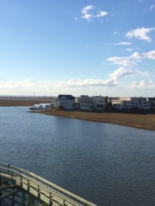
View From the Marina Looking Toward the IC
Yesterday we Uber’ed in to Charleston and toured Fort Sumter where the opening shots of the Civil War were fired. South Carolina, first state to succeed from the union by a unanimous vote of the state political leaders. For the first time we saw a Confederate memorial. The northern states have none. I take it back, there was a Confederate memorial at an intersection in Arlington, VA, but it’s not popular with the locals and they want it taken down.
Fort Sumter
We are thankful for good weather, good food and Good Karma! Tomorrow we continue the adventure!
South Carolina Beach
Posted in Sailing by Mark with comments disabled.
ICW Mile 462: Charleston, South Carolina
Sunset During the Overnight Passage
Earlier today we completed another big jump around the ICW ditch as well as another first: An overnight sail. We decided to make one big jump offshore below Cape Fear rather than dealing with the problems of the channel. Shelly researched the options (as she has done for the last month) and the shortest hop we could do was a 60-plus miler which involves a long sailing day with either the beginning or ending in the dark. So we decided what the hell, let’s go overnight and get all the way to Charleston, the advantage being we begin and end in the daylight and cover a lot of miles.
The last night in Cape Fear was cold, getting down into the 30s F, and we were getting annoyed about constantly dealing with the fact that we left late in the season. We were also getting more concerned about avoiding winter storms that may form on the east coast this far north. And avoiding the ICW itself is always a good thing, so our plan was to cover approximately 135 miles in one shot. You can of course sail all the way to Florida and beyond from here in about 3 days, but we are also trying to ease into long passage making and a multi-day crossing was probably not a good step for us at this point.
So the story: We made a leisurely exit from the marina at Cape Fear at about 10:30 a.m. and headed southwest, following the coastline. The promised northwest wind happened to be from the west or southwest for most of the day, making progress slow. Over time the wind swung mildly west to northwest. Late afternoon faded to evening as we watched the sunset. It was strikingly red-orange due to many fires raging in this drought-stricken region.
Our plan was to take two hour shifts over the night but it didn’t work out that way. Shelly was too excited and concerned to sleep much and she only got about two hours sleep around midnight and another early in the morning. I tried to sleep on my breaks but it wasn’t easy. We had prepared to sail overnight with our smaller staysail, setting it up at dusk and that worked out well.
The only weirdness in the night was when a sailboat suddenly showed up on Shelly’s watch. It appeared on the AIS a few miles in front of us but Shelly couldn’t see any lights. She monitored the AIS track for a while because we were on a collision course. Because she couldn’t see the other boat, even in the relatively bright moonlight, she tried to spotlight it with our bright light. Very soon afterward they turned their running lights on (they’re supposed to be on all night in coastal waters), presumably because they saw us. This was at about 2 a.m. Shelly thought someone was sleeping or they just weren’t paying attention, it was a too-close encounter in what should be a big ocean.
We watched as thousands of stars rose over the horizon and arced overhead as the night progressed. The half moon rose at about midnight. A really cool thing I noticed is that you could see stars so low on the horizon they looked like sailboat lights, something almost impossible to see on land. The night was surprisingly warm and the wind increased from the north. We had to reef the sails a couple of times. Sometime after about 5:30 a.m., the sky began to brighten and soon after we found the sun also rises (sorry Hemingway).
We still had many hours to go and had to fight the waves to get into the Charleston harbor entrance. Got to a marina about 25 hours after leaving. Success!
Cape Fear Rest Day
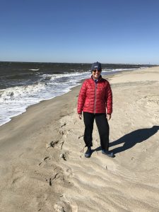
Shelly Models Her “November in North Carolina” Beachwear
We went for a long walk today around Cape Fear, windy and brisk in November. No beachgoers but blue skies without a cloud in sight. It was cold enough that we had to wear our winter beach clothing, as Shelly shows above. The island is replete with empty vacation homes, it reminded us of the resort area in Steamboat, nice big houses with no one home. No cars are allowed on the island, but speeding golf carts are a problem as we found walking down the roads. The only way to get here is by ferry (or your own boat) that comes once an hour and costs $23 one-way from the nearest town of Southport.
We walked past the Cape Fear lighthouse, pic below. Originally built in 1789. The island was prominent in both the Revolutionary War and the Civil War. In the Civil War it was one of the last Confederate holdouts whose forts have now been submerged due to climate change.
We hunted for alligators but didn’t find any. Probably too cold!
Cape Fear Lighthouse
ICW Mile 309: Cape Fear Inlet
Sunset Over Good Karma
Got up early today and motored about 25 miles down the ICW to the Cape Fear inlet. Lots of funkyness. The channel was narrow and very busy, mainly with private fast-moving fishing motorboats. The main challenge was dealing with the high currents in the channels that make it difficult to control the heading and speed. The tidal range has been about 5 feet and that equates to a lot of water moving in and out of narrow openings. You can see the effects around the channel marker posts and buoys, they appear to be in a fast moving river with a wake behind them.
We had to get moving early again today to get under a bridge at relatively low tide. After the bridge the current was hard against us so it took about two to three times as long to get to our destination, making the day about 6 hours before we docked.
Our marina is on Bald Head Island, my kind of place! It’s fairly protected for the gale force winds expected tonight and tomorrow. We are here for two nights to wait out the front coming through. Today was nice but windy but the next few days promise to be cold. The tradeoff for us is all the marinas and anchorages we have stayed in have been sparsely populated.
On a learning note: We got way too close to a dredging operation in the channel, pic below. You are supposed to remain 500 feet away because they anchor these barges on long cables. We happened to cross over at least one of those cables trying to stay in the channel and not knowing what exactly was going on. We hightailed it away when we figured out what was going on, being lucky not to have hit a cable.
Our improvised radio has been working but not ideal. We were probably warned about this operation but didn’t understand the distorted signal due to having the radio volume too high. Now fixed.
Tomorrow is a well-earned rest day. Going’ to hunt gators!
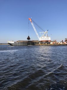
Big Dredging Operation in the Channel
Posted in Sailing by Mark with comments disabled.
ICW Mile 285: Masonboro Inlet

Crews Work In Predawn Hours on a Grounded Ship
Big, big day today. Accomplished a few firsts. We had our longest transit to date, about 70 miles across Onslow Bay between Cape Hatteras and Cape Fear, NC. We had our first open ocean sailing experience on Good Karma, and for the first time (for me anyway), I was far enough out to sea on my own boat as to not have any visible land anywhere. The caveats here are that we barely had a “sailing” experience today because the wind was so mild, and we were only 15 miles from land at any time, so it wasn’t like real open ocean sailing.
So here was the deal: Here you can go out to the Atlantic and bypass about 80 miles of some of the worst parts of the ICW channel but it’s a long day. To do this you exit to the sea at the Beaufort Inlet south of Cape Hatteras. The nearest return is the Masonboro Inlet just north of Cape Fear. It takes about 12 hours to get across this section under moderate conditions, from leaving dock in the morning to anchoring at night. Being the third week of November, there are only about 11 hours of daylight, counting the predawn and post-sunset useable twilight. So you have to do something in the dark and we chose to leave at zero dark thirty.
We winded down and out the Beaufort Inlet channel relying heavily on navigation instruments as we did a few days back when our anchor drug. This time we were avoiding other boats doing the same thing, as well as UNLIT anchored boats (what are these people thinking?!?) on the exit route. It was a bit harrowing, but we made it ok. As we got out to the ocean we passed a big cargo ship that had gone aground the day before. Crews were working frantically to get it unstuck, we could hear them shouting as we passed (above pic).
After we got out to sea we had enough wind to motorsail. The wind direction and speed was not enough to give us the velocity we needed to get to our destination in a reasonable time so we had to motor the entire way. Our engine droned on for twelve straight hours. The sails did give us an extra knot of speed, though, which over the long run shaved more than an hour off our motor-only time. And we needed it. The sun set just as we got an anchor set. Anchoring in the dark would not be anyone’s idea of fondly remembered good times, especially when there are many other UNLIT boats anchored in the area, as there are here.

The Path of Good Karma is Not a Straight One
Our AIS seems to be tracking well on the website. The above track shows an overview of today’s route. Note that it is not a straight line as you might expect, but bows toward the ocean. This is what you must do to avoid the Camp Lejeune live firing range, which extends 15 miles offshore. The military uses this range every day. We heard lots of rumbling booms of the live firing but didn’t receive any direct hits, which is a good thing…
The coolest thing we saw today was again, the dolphins. Two times we were escorted by a group who seem to think Good Karma is a giant dolphin. They always gather around and swim right next to us for five or ten minutes sometimes. The first group came in and were jumping occasionally but not a lot, so Shelly walked up to the bow and looked down. They were swimming right in front of the boat and along side as if to guide us. Three of them were leading, two adults and a young one. I got a great video of two of them, the little one is visible only in the first couple of seconds unfortunately. I had to name the little one “Bob” at the request of our niece Hannah who would probably want us to ship it home for her.
Great progress south today, it even feels warmer!

Sunrise Over The Atlantic
Posted in Sailing by Mark with 2 comments.
Busy Day in Beaufort

Old Radio Out, New One In
We spent most of the day today shopping, doing laundry and trying to get a new workable radio set up. Caught a ride into town with another crew that is getting their boat repaired, we were going to the same marine supply store and grocery store. Bought some bibs, deck shoes, life lights (lights for our life vests) and a new VHF radio.
The old radio worked fine but the remote control head started flaking out. The radio itself is below deck at the electronics station, but it’s generally worthless there because you can’t use it from the cockpit from there. The remote control head allows you to talk, listen, change channels and volume from the cockpit. That is about the only place you use the VHF radio, so it’s critical to get fixed. The marine supply store of course did not have the entire system, so we are here until Thursday at least.
I did get the radio mounted, which is the white radio in the above pic. The hole in the wall is where the old radio was mounted. Looks a bit ugly at this point but we will clean it up in Florida when we get to a long layover point.

Sunset Off the Starboard of Good Karma
Posted in Sailing by Mark with comments disabled.